Italiano
 Deutsch
Monte Giovo

Spectacular ultra-panoramic tour that has its highlight in the very long descent from the summit of Mount Giovo. A very suggestive passage is in the valley called Campi di Annibale, just below the ridge that we are going to ride. The tour is classified for experts because of the challenging section with bike on the shoulders from the Boccaia pass to the summit of Giovo and the descent that is very challenging in places. For lovers of the genre, not to be missed.
From Barga follow signs for Ponte di Catagnana Renaio Vetricia, past the bridge over the Corso stream but park the car nearby.
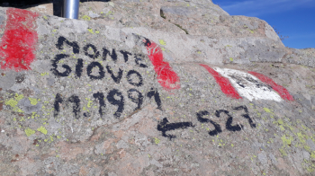
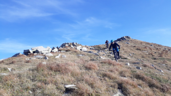
Start immediately uphill towards Renaio, past the village follow signs for the Giovanni Santi refuge at Vetricia (CAI path 20). From the refuge continue by forestry to an altitude of about 1650 where we will continue along the watershed trail until we reach the Porticciola pass. At an altitude of 1580 on a hairpin bend you can stop at the Caccia bivouac where there is also a water point. From the pass we take CAI trail 529 downhill rideable with some short sections where it is recommended to descend.
Passing through the Fields of Hannibal we arrive at the Boccaia pass from where we will begin the ascent to the summit in a grueling section with bike on our shoulders. Reaching the summit we are going to descend on the spectacular and super panoramic ridge that takes us back to the Porticciola pass, we then continue along the CAI 20 path cutting the forestry made in the morning. Near the Santi refuge we take CAI path 30, another spectacular trail until we reach the dirt road that leads us back to our starting point.
Performed on 10/16/21