Italiano
 Deutsch
Gran tour Apuane Meridionali

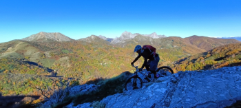
Cycloexcursion as challenging as it is exciting on the paths of the Southern Apuan Alps. This area of the well-known mountain range, in fact, is the one that is most suitable for MTB riding. It should be pointed out, however, that you will often need to load the bike on your shoulders. Depart from Piegaio and go immediately uphill on the main asphalt road in the direction of Pescaglia, continuing on to Passo Sella. From here, you leave the main road to take the road that leads to Groppa where, once you arrive, forget about the asphalt because you will never see it again and get ready to tackle the rugged Apuan terrain.
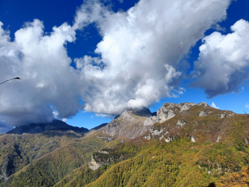
It climbs along the sent. CAI 103, which traverses the entire northern slope of Mount Piglione, until you reach the Foce del Termine (or Crocione). Bike back up and climb the trail to the Foce del Pallone. Back in the saddle and down to the meadows of Alto Matanna. Just below the parking lot we find the sent. CAI 3 to Palagnana. This trail turned out to be a pleasant surprise: technical, steep and with some pitfalls hidden under the leaves, in about 20 minutes (as opposed to the 50 indicated by the trail marker at the beginning) it takes us to Palagnana, more precisely to the locality Il Ferro. Now begins the beautiful mule track coinciding with sent. CAI 8 that climbs in the direction of Foce delle Porchette.
The first part is all pedalable, the central part is best done with bike on the shoulder, while the terminal part becomes pedalable again. Once we reach the mouth, we continue on sent. CAI 8, also known as the "little Vandelli," descending on the opposite side of Mount Nona. A path full of hairpin bends, with a very bumpy bottom and requiring excellent technical driving skills.
Still on CAI 8 we reach Colle del Prato where we continue on CAI 5A/121/106, a combination that leads to the Forte dei marmi Marmi Refuge at Alpe di Grotta.
Arriving near the aforementioned refuge, we take the beautiful trail that leads to the Foce di Grattaculo. In a continuous "eat&bevi," long pedaled stretches alternate with small interruptions where it is necessary to get off the bike and push it to overcome the obstacle of the turn. When we reach the mouth we intercept the path that will take us back to the Foce del Pallone. The previous discussion applies here as well: long stretches where you can pedal and some passages where you are forced to resort to portage. From the mouth we descend by the stony trail to Termine. After that, portage again awaits us for a few meters of elevation gain, returning to pedaling to the beginning of the ascent of Mt. Piglione.
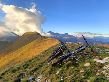
?More portage until the first drop, then you can pedal quite well for a good stretch, while the final part to get to the ridge will have to be done with the bike on your back. Now we run on the ridge heading south, with the plain of Lucca in front of us and the Monti Pisani in the background. After the summit cross the ridge becomes very steep and we follow it for a few dozen meters. Then we turn sharply left onto a half-steep path that, following it all the way, will lead us to come out on the asphalt road to Ritrogoli. We are not in time to touch the asphalt that we immediately abandon it to slip onto the "Indian trail." Another path full of pitfalls and not at all obvious, especially at the end of a day like this. From the 900m asl at the entrance, we arrive at the 350m asl of Convalle, a small hamlet in the municipality of Pescaglia. The tour can be said to be over, in fact, in a few minutes we are back at the starting point.