HOME RANKINGS CHALLENGES ROUTES POI PLANNING SEARCH LOGIN
Italy - Trentino-Alto Adige/Südtirol, BZ
2022/10/22 20:40:49

Somamunt da Monguelfo

11 Downloads
2
 
Share
Author
nonnocarb
(292)
Place
Italy - Trentino-Alto Adige/Südtirol, BZ
Km
45,86 km
Elapsed time
04:23:23
Vertical meters
+1 661 mt (1060 - 2274)
Route difficulty
Landscapes
Last update
2022/10/22 20:51:24
Comments
0
Description

Very challenging itinerary for both the steep ascent and the technical descent, but also very enjoyable and scenic.

From Monguelfo take the bike path to Valdaora, climb to Bagni di Pervalle and then to the Furcia pass all on dirt roads and trails.

At the pass you descend into Val Badia and then climb up the challenging forest road to the Somamunt pass, with the last km very steep.

A beautiful view of the Braies Dolomites opens up from the pass and you take a fun trail at altitude, which then connects to the trail down into the valley, which is fun but technical.
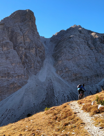
The trail first comes out in the Foresta valley
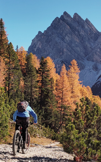
and then comes to Lake Braies. Here one must be careful of the many hikers present.
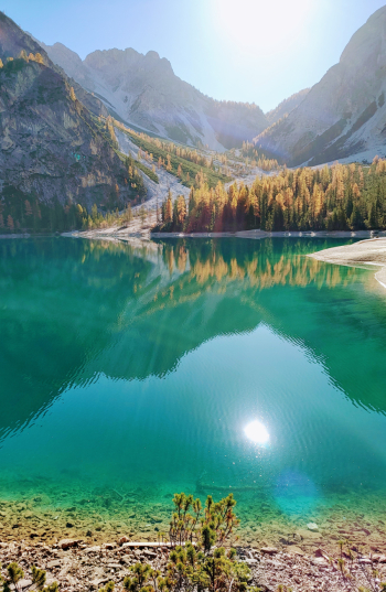
From the lake you descend on the fun trail 1 and then on a bike path back to Monguelfo.

Download our free mobile app to send this route to your Garmin device or to navigate it on OSM maps. Android - iOS
Local weather
°C
°C
°C
°C
°C
°C
°C
°C
°C
°C

Graph

Nearest Routes

2024/06/05
- Italy - Trentino-Alto Adige/Südtirol, BZ
30,77 km
Km
+1 400 mt
Vertical meters
Route difficulty
Landscapes
2023/03/05
- Italy - Trentino-Alto Adige/Südtirol, BZ
nonnocarb
(292)
45,98 km
Km
+1 400 mt
Vertical meters
Route difficulty
Landscapes
2023/02/26
- Italy - Trentino-Alto Adige/Südtirol, BZ
nonnocarb
(292)
53,06 km
Km
+220 mt
Vertical meters
Route difficulty
Landscapes
2024/07/25
- Italy - Trentino-Alto Adige/Südtirol, BZ
nonnocarb
(292)
56,06 km
Km
+1 900 mt
Vertical meters
Route difficulty
Landscapes
2023/03/04
- Italy - Trentino-Alto Adige/Südtirol, BZ
nonnocarb
(292)
37,05 km
Km
+1 550 mt
Vertical meters
Route difficulty
Landscapes
2023/02/26
- Italy - Trentino-Alto Adige/Südtirol, BZ
nonnocarb
(292)
35,05 km
Km
+505 mt
Vertical meters
Route difficulty
Landscapes
2023/03/01
- Italy - Trentino-Alto Adige/Südtirol, BZ
nonnocarb
(292)
76,61 km
Km
+2 400 mt
Vertical meters
Route difficulty
Landscapes
2023/03/04
- Italy - Trentino-Alto Adige/Südtirol, BZ
nonnocarb
(292)
71,87 km
Km
+1 820 mt
Vertical meters
Route difficulty
Landscapes
2023/02/26
- Italy - Trentino-Alto Adige/Südtirol, BZ
nonnocarb
(292)
28,41 km
Km
+510 mt
Vertical meters
Route difficulty
Landscapes
2023/03/06
- Italy - Trentino-Alto Adige/Südtirol, BZ
nonnocarb
(292)
30,64 km
Km
+890 mt
Vertical meters
Route difficulty
Landscapes

0 Comments