HOME RANKINGS CHALLENGES ROUTES NEAR ME PLANNING SEARCH LOGIN
Italy - Toscana, LU
2026/08/24 21:39:03

Diecimo, Groppa, monte Piglione, CAI 102

0 Downloads
0
 
Share

Key Takeaways / Scheda Tecnica

Disciplina:
Mountain Bike (MTB)
Percorso:
Diecimo, Groppa, monte Piglione, CAI 102
Località:
Italy - Toscana, LU
Distanza:
42,70 km
Dislivello Positivo:
+1 200 mt (Quota Min: 71m - Max: 1183m)
Difficoltà Tecnica:
4/5
Valutazione Panorami:
4/5
Formato Traccia:
GPX Download disponibile
Author
Seraffo85
(21)
Place
Italy - Toscana, LU
Km
42,70 km
Elapsed time
06:16:07
Vertical meters
+1 200 mt (71 - 1183)
Route difficulty
Landscapes
Last update
2026/08/25 07:34:22
Comments
0
Description

The tour (starting from the Diecimo-Pescaglia train station, easily accessible from Lucca) is a sweeping loop with a distinct Apuan character, ideal for those seeking the perfect balance between scenic climbs and descents that are never predictable. The first part of the climb flows smoothly along paved roads through Piegaio, Trebbio, Pescaglia, and Groppa, before changing pace at the start of CAI Trail 103. This trail proves to be one of the absolute best high-altitude rides, offering spectacular views of the southern Apuan Alps and the Panie range. To reach the summit of Monte Piglione, you’ll need to carry your bike on your shoulder—though there are a few short sections where you can still ride—but the effort melts away the moment you take a well-deserved break at the top, enjoying a sandwich and snapping countless photos of the 360° panorama.

The descent begins immediately with a steep climb up the southern ridge of Monte Piglione, where the loose terrain and steep gradient demand maximum attention and a watchful eye. Once you reach and follow the paved road toward Ritrogoli and Ranchiani, you’ll come to the entrance of CAI Trail 102, which has recently been impeccably restored by volunteers from CAI Lucca. The trail is a mix of pure rock and technical riding typical of the Apuan Alps—always varied and fun—which, before reaching the Galgani Ironworks, offers a final stretch that’s wonderfully “flowing” yet maintains a steady rhythm. From here, the easy return along the paved road toward Diecimo lets you stretch your legs after a ride that demands solid technical skills and offers great satisfaction.

Spring and fall are the best times to ride. In the height of summer, there are horseflies and plenty of ferns in some sections. In any case, the route proved to be completely rideable.
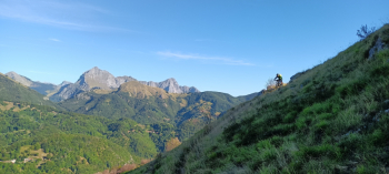
Foto itinerario MTB Diecimo, Groppa, monte Piglione, CAI 102 - Italy - Toscana, LU

Download our free mobile app to send this route to your Garmin device or to navigate it on OSM maps. Android - iOS
Local weather
Tue 00:00
15 °C
Tue 12:00
20 °C
Wed 00:00
19 °C
Wed 12:00
19 °C
Thu 00:00
16 °C
Thu 12:00
18 °C
Fri 00:00
12 °C
Fri 12:00
15 °C
Sat 00:00
15 °C
Sat 12:00
16 °C

Graph

Nearest Routes

25,04 km
Km
+1 351 mt
Vertical meters
Route difficulty
Landscapes
2023/01/03
- Italy - Toscana, LU
ebsat
(129)
36,21 km
Km
+1 697 mt
Vertical meters
Route difficulty
Landscapes
28,80 km
Km
+1 440 mt
Vertical meters
Route difficulty
Landscapes
2023/03/04
- Italy - Toscana, LU
giobike73
(49)
28,80 km
Km
+1 539 mt
Vertical meters
Route difficulty
Landscapes
2023/06/29
- Italy - Toscana, LU
ebsat
(129)
32,67 km
Km
+1 300 mt
Vertical meters
Route difficulty
Landscapes
2023/03/02
- Italy - Toscana, LU
giobike73
(49)
20,51 km
Km
+731 mt
Vertical meters
Route difficulty
Landscapes
2023/03/02
- Italy - Toscana, LU
giobike73
(49)
78,12 km
Km
+2 090 mt
Vertical meters
Route difficulty
Landscapes
2023/06/28
- Italy - Toscana, LU
ebsat
(129)
33,83 km
Km
+1 590 mt
Vertical meters
Route difficulty
Landscapes
2023/01/29
- Italy - Toscana, LU
ebsat
(129)
21,42 km
Km
+1 105 mt
Vertical meters
Route difficulty
Landscapes
2024/12/22
- Italy - Toscana, LU
ebsat
(129)
30,65 km
Km
+1 545 mt
Vertical meters
Route difficulty
Landscapes

0 Comments