
 Italiano
 Deutsch
Magnodeno e Passo del Fo: il balcone tecnico sul Resegone

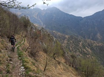
A granite loop dedicated to those who live for technical riding and aren’t afraid of carrying their bikes. On this expedition through the Lecco foothills, riding the bike is an achievement: from the S3/S4 sections along the hillside to the rocky, physically demanding sections heading down the valley, every meter demands precision and control. It’s a route for those seeking the adrenaline of the passes and the rugged beauty of the Resegone, far from tourist crowds and well-trodden paths.
Ascent
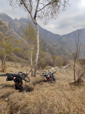
The first part lets you warm up your legs: the climb is steady and fully rideable in the saddle all the way to the Piani d’Erna Cable Car plaza. From here on, the landscape changes radically: the terrain becomes hostile and the gradient extreme, making progress a challenge for “aliens.” Once the rideable section ends, brace yourself: about 250 meters of carrying the bike on your shoulders await you to conquer Magnodeno. Note: not recommended for e-bikes due to the complexity of the trail during transport.
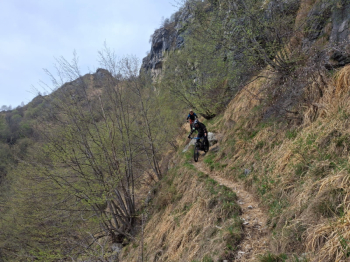
From the summit of Magnodeno, the view of the lake is breathtaking, but the best is yet to come. You take a spectacular ridgeline trail toward Passo del Fo. First comes a technical S3 section with S4 passages, at times somewhat exposed; subsequently, it becomes a push for about 15–20 minutes, where your gaze inevitably falls on the majesty of Resegone dominating the horizon. A stretch of pure adrenaline and alpine beauty.
Passo del Fo and Capanna Monzesi
Once you reach the fork, continue hiking to Passo del Fo (or you can cut straight across toward Capanna Monzesi). From Fo, a physically demanding S3 descent begins, leading straight to Capanna Monzesi. Here, the terrain is rugged and rocky, typical of the Lecco spurs.
Final Descent: Rock and Technique to Erve
From the Monzesi Hut, the long descent back to the valley begins. The trail is a succession of S3 and S4 sections: very technical, with plenty of rock requiring constant work from your arms and suspension. It’s never as extreme as the 17a on the Sileggio, but it doesn’t give you much of a breather; it offers respite, but only enough to prepare for the next section.
The grand finale takes us toward the Erve area: from the cross, with its spectacular view of the lake, the trail eases slightly, becoming an enjoyable S2/S3 enduro section that’s still nicely challenging, which, after a subsequent slightly XC-style trail, leads us to the final turns of this epic loop.
Technical Specifications
- Trail Style: All-Mountain / Technical / Adventure
- Personal Rating: Views 8/10; Descents 8/10
- MTB: Yes
- EMTB: No (portage on the trail is too difficult for heavy bikes)
- Duration: approx. 8h
- Carrying distance: approx. 400m total (and possibly more)
- Ascent difficulty: Challenging (rideable only up to the cable car)
- Descent difficulty: S3 / S4 (technical, lots of rock, final section more flow S2)
- Exposure: Panoramic hillside, exposed in places; descent from the Monzesi hut with short exposed sections
- Tracking: Better with dry rock
- Water: A few fountains after Capanna Monzesi on the descent
Alternatives:
- You can head straight to Capanna Monzesi without passing through Fo if you want to save yourself some carrying.
- The final section toward Erve offers interesting trail alternatives to finish the loop with various S2 sections.


