
 Italiano
 Deutsch
Magnodeno hardline

Forget bike parks and perfectly groomed trails. Here, we’re talking about mountain biking in its rawest form, where rock reigns supreme and trial-style technique is the only way out. The Magnodeno Hardline is a brutal, spectacular, and relentless route, designed for those who want to see where the bike’s limits end and the rider’s begin.
The Ascent Part 1: (Artificial) Paradise
We start from Lecco, heading straight for the Piani d’Erna cable car station. From here, for those who want to maximize fun and the descent, the choice is clear: load your bikes onto the cable car (cost about 10 euros) and head up to Piani d’Erna. From the upper station, you immediately hit a rough S3/S4 trail—a carpet of loose and solid rock that instantly makes it clear what the Lecco terrain is made of. After this technical “taste,” you rejoin the ascent road to continue climbing toward the main destination.
The Climb Part 2: Hell (pedaling and carrying)
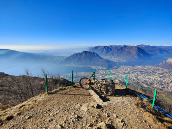
Back on the road, the tune changes. A series of “eat-and-drink” sections with prohibitive gradients begins. There’s a stretch of about 150 meters where the challenge becomes total: either you have superhuman legs or you get ready to push, because here the traction and the slope put even the most powerful E-MTBs to the test. Once you’ve overcome this ordeal, the final push awaits: a portage section and a short, well-maintained path (nothing complicated) that serves as the gateway to the summit of Magnodeno. Here, the 360° view of Lake Lecco is a perfect 10, but it’s just the calm before the storm.
The Ridge: Pure Adrenaline
The descent begins directly on the summit ridge. The first section is a vertical wall featuring S4/S5 sections where bike control is everything. The route then continues along the ridge: the gradients ease slightly but the technical challenges remain constant, with some seriously tough sections that allow for no distractions. You are constantly caught between the majesty of the panorama and the ferocity of the trail.
Hardline: Rock and Trial Riding
We enter the heart of the trail: an extremely technical and rocky path. Here, there is only one rule: ride strictly in dry conditions. It is an endless succession of S4 and S5 sections, where the nose press becomes your best friend and reading the line makes the difference between staying in the saddle or getting off and walking.
The Finale: Vicerola’s Smile
Once you reach Erve, the hard work isn’t over. A climb takes us to the Croce di Vicerola. From here, finally, the trail changes pace: a fast and fun S2 section, with a few S3 sections to keep you on your toes, lets you let go of the brakes and enjoy the speed. A final stretch of “easy riding” brings us back to the starting point: tired, worn out, but with a smile plastered on our faces that only the Hardline can give.
Trail style: All-mountain
Personal rating: Views 9/10; Descents 9/10
MTB: Yes
EMTB: Yes (watch out for portage)
Duration: approx. 6-7 hours (by MTB)
Portage: 200–300 m
Ascent difficulty: Very demanding
Descent difficulty: S4 (moderate) with S5 sections
Exposure: Exposed sections on the ridge, which you don’t have to ride
Weather: I recommend waiting for dry days
Water sources: Mountain hut after the climb to Piani d’Erna


