Italiano
 Deutsch
Monte Salvaro e Monte Pezza

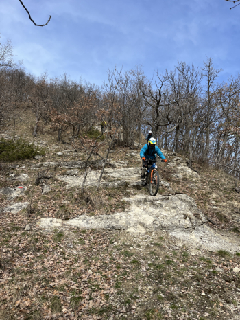
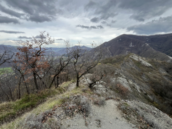
Start from the Vado parking lot. After a good cup of coffee, follow the paved road to La Quercia, where you turn right and climb up to Rivabella. Here, take the trail on the left (Cai). Caution: this uphill section is prone to mud, so it’s recommended only during dry weather. Alternatively, stay on the paved road to S. Martino, then turn left onto the dirt road to rejoin the trail shortly after Le Scope. After the climb on the trail, you’ll reach the dirt road (Cai 51) and turn left here toward M. Salvaro. At the intersection with the road ascending from Gardelletta, continue for a short distance (uphill) until you reach the Cai 100 trail leading up to Monte Salvaro. The trail climbs gradually in the first section, with good footing on smooth rock and well-drained terrain, and a few steep sections toward the end. You arrive a few meters from the Monte Salvaro Cross and turn left here to take the ridge trail (parallel to the descending Cai 100). The trail is a single track with some exposure and is fast-flowing, but features a series of challenging technical sections on rock, leading to the crossroads below Monte Pezza.
Here, turn left and finish the descent with a fun, flowing toboggan run. Turn right onto the paved road toward Ca Mascagni and continue on CAI 100 (this section is also prone to mud on the uphill stretch, though it’s short). You’ll arrive in the village of Castello via a trail and then on paved road. Shortly after Torre Terme, a trail begins that climbs gradually up to Carviano, and from here the final trail starts; a flow trail (the first section is muddy but not too bad), but then near a ditch, turn right, and the second section is definitely more fun (still flow with a few more technical sections). You’ll reach the road to climb back up toward Salvaro and from there toward Monte Sole. Follow the dirt road and then the paved road through San Martino, Caprara di Sotto, and past the Casaglia cemetery to reach the Cai 55 (a flowing single track with some higher sections prone to mud) which takes you back to Le Murazze and shortly thereafter to Vado.
Route difficulty: S3 (some sections S4).