Italiano
 Deutsch
Dalla Val Mastallone alla Val Sermenza
Loop tour starting in Varallo Sesia, joining the Mastallone and Sermenza valleys at the foot of Monte Rosa.
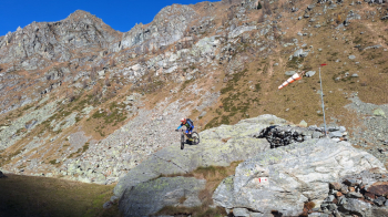
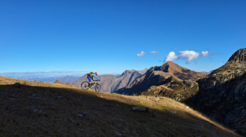
Start from convenient camper parking area in Varallo Sesia. You skirt the Mastallone and as soon as you reach the first bridge cross over and take a mule track that then becomes a path and allows you to avoid a few kilometers of bitumen. You return to the road and climb in the direction of Fobello passing through Bocciolaro, Cravagliana, Ferrera. Just before Fobello, near a Roman bridge, cross over and go across the river to avoid another piece of asphalt. When you reach the hamlet of Santa Maria, take a mule track to be done in stretches by pushing and a few pedal strokes until you reach Alpe Baranca (1,600 meters). Continue uphill to Lake Baranca, an emerald-green mirror in a magnificent valley. Continue on arriving at Alpe Selle and the remains of Villa Aprilia. Just before this you take the GTA that allows you to reach (always pushing) Col d'Egua (2239 m.), a magnificent pass that connects Val Baranca with Val d'Egua and then from Lake Rimasco becomes Val Sermenza.
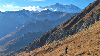
Small stop at the Bivacco (2260 m) and before starting the descent we stop to admire the magnificent view of Monte Rosa. The fun begins with endless descent on mule-track-sentiero and you reach the Boffalora G.P. Majerna Refuge (1685 meters). Continue on and you reach Carcoforo (1304 meters). Here you immediately take a mule track that allows you to reach the hamlet of Ferrate on a dirt road. Continue downhill on asphalt to the hamlet of Chiesetto, then with a short ascent you reach Priami from which you descend again on a mule track to Rimasco. Bitumen up to Cerva where staying high you take a path through the woods that allows you to avoid more asphalt and comes out at Guaifola. Return passing through the hamlets of Vocca and Valmaggia and return to Varallo.