HOME RANKINGS CHALLENGES ROUTES NEAR ME PLANNING SEARCH LOGIN
Italy - Trentino-Alto Adige/Südtirol, TN
2025/09/19 20:04:14

Val Sorda e Laghi di Pisorno

15 Downloads
0
 
Share
Author
Place
Italy - Trentino-Alto Adige/Südtirol, TN
Km
30,55 km
Elapsed time
07:11:34
Vertical meters
+1 550 mt (1466 - 2286)
Route difficulty
Landscapes
Last update
2025/09/20 08:09:50
Comments
0
Description

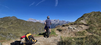
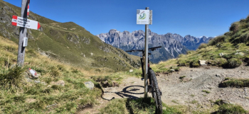
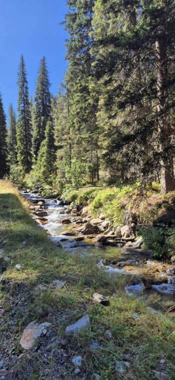
Starting from S. Martino di Castrozza, on hard dirt road you reach Malga Tognola. On stupendous rockgarden never trivial you descend into Val Tognola and reach Valsorda, after dozens of small stream crossings. You go all the way up it on forestry skirting the stream, all in a typical alpine environment with thrilling views. After the malga of the same name a last stretch on a technical uphill trail, and you reach Forcella Valsorda. Traverse to Forcella Folga, on a path that is exposed in places, with several pushing sections.

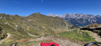
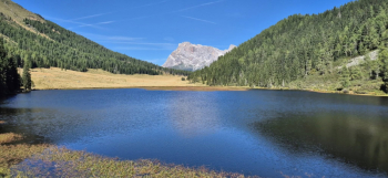
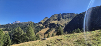
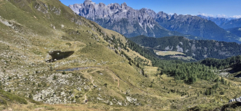
Another traverse first downhill then uphill in exposed sections, almost all in the saddle pedaling to over 2100 elevation with views of Pale San Martino and small lakes below. Reaching the Val Pisorno saddle you descend on exposed and technical singletrack to the Laghetto below. In the woods the trail becomes Incattivisce, with challenging switchbacks and rockgarden, to the stunning Calaita Lake. The return to St. Martin is on dirt road with a short segment on fun trail. Up to Calaita Lake the trail is very unfrequented and the environments are wild. For those who want to save km and elevation gain, you can take the cable car up to Malga Tognola.


Download our free mobile app to send this route to your Garmin device or to navigate it on OSM maps. Android - iOS
Local weather
Fri 00:00
10 °C
Fri 12:00
13 °C
Sat 00:00
10 °C
Sat 12:00
11 °C
Sun 00:00
10 °C
Sun 12:00
16 °C
Mon 00:00
11 °C
Mon 12:00
17 °C
Tue 00:00
11 °C
Tue 12:00
16 °C

Graph

Nearest Routes

2024/01/02
- Italy - Trentino-Alto Adige/Südtirol, TN
@ff.mtb
(9)
53,65 km
Km
+1 800 mt
Vertical meters
Route difficulty
Landscapes
2023/03/09
- Italy - Trentino-Alto Adige/Südtirol, TN
civi65
(106)
38,63 km
Km
-2 300 mt
Vertical meters
Route difficulty
Landscapes
2023/02/26
- Italy - Trentino-Alto Adige/Südtirol, TN
nonnocarb
(319)
17,68 km
Km
+770 mt
Vertical meters
Route difficulty
Landscapes
2023/02/26
- Italy - Trentino-Alto Adige/Südtirol, TN
nonnocarb
(319)
19,49 km
Km
+790 mt
Vertical meters
Route difficulty
Landscapes
2023/07/17
- Italy - Trentino-Alto Adige/Südtirol, TN
gmr
(4)
42,95 km
Km
+1 500 mt
Vertical meters
Route difficulty
Landscapes
47,96 km
Km
+1 788 mt
Vertical meters
Route difficulty
Landscapes
2022/12/13
- Italy - Trentino-Alto Adige/Südtirol, TN
Staff
(108)
49,88 km
Km
+1 025 mt
Vertical meters
Route difficulty
Landscapes
2022/08/12
- Italy - Veneto, BL
gmzolenart
(125)
18,78 km
Km
+873 mt
Vertical meters
Route difficulty
Landscapes
2023/07/11
- Italy - Trentino-Alto Adige/Südtirol, TN
27,71 km
Km
+1 560 mt
Vertical meters
Route difficulty
Landscapes
2022/11/19
- Italy - Trentino-Alto Adige/Südtirol, TN
58,20 km
Km
+3 100 mt
Vertical meters
Route difficulty
Landscapes

0 Comments