Italiano
 Deutsch
Punta della Mulattiera, Colletto del Gui e Lac Chavillon

Route loosely inspired by this tour, but with a few strategic tweaks: shortened and optimized uphill to save legs (and dignity), without sacrificing the beautiful descents. Departure from the convenient parking lot in front of the chairlift in Melezet, Bardonecchia. For 11 Euros, we get shuttled up to an altitude of 1,800 meters, saving us some energy.
From the top station, two options to start:
- follow the trail and go up along the ski slope (mostly pushing)
- or descend about 150 meters following bike park trail 20 to Pian del Sole and then climb back up a decidedly friendlier dirt road.
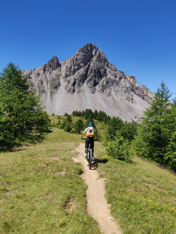
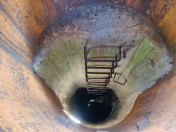
Either way, you'll find yourself at the top of Mulattiera Pass after a few bike-pushing sections. At Mulattiera Pass we find the remains of tunnels and a barracks.
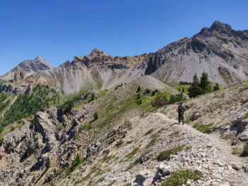
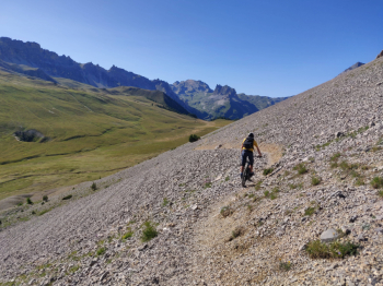
We set off on the first descent. Despite the obvious signs of the last floods, the trail is still a spectacle. We dance on the ridge between tracks in the middle of meadows and postcard views. We arrive below the Tour Jaune de Barabbas, where channels dug by the storms force us to walk a few stretches: be careful here, but nothing tragic. We push/shoulder the bike for 10 minutes up to the saddle and start again in the saddle for a nice, easy, flowing traverse to the ascent to the Colletto del Gui, where we are greeted by more bunkers and remnants of the war.
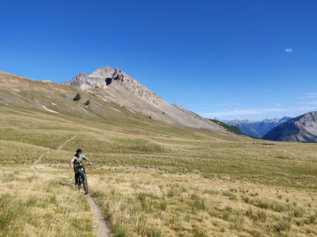
Technical switchbacks with fixed rock, roots and nose-press galore. It's tough with lots of lines to choose from, but entirely cyclable. We arrive at the Col de l'Échelle road, with bonus final bunker (explorable if you have little spirit of self-preservation and lots of spirit of adventure . We continue on asphalt toward Névache, but before the road descends ?zac! little path to the right pointing toward the Aiguille Rouge. Start with bike on the shoulder, but slowly becomes rideable and almost enjoyable. Arrived at altitude 2350 we wisely decide not to climb to the top: no water no party.
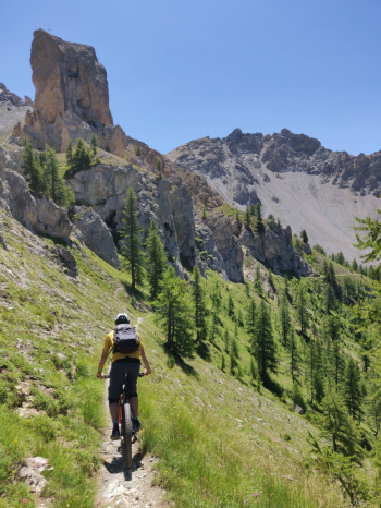
First wonderful traverse on steady stones to Lac Chavillon, with Mount Thabor in the background dominating the view. From the lake, we change pace: stretches in the meadows, then an enchanted forest with textbook hairpin bends. Pure fun and never too technical. It could go on forever, but you reach the Re Magi Refuge and, miracle: the first drinking fountain of the tour.
Last part towards the valley floor: a fast trail, which looks like a natural pump track, takes us to the Melezet Dam. When you think it's over, the last treat begins: super flow trail, with natural banks and jumps. A real icing on the cake, leading us straight back to the parking lot.
Conclusions
A ride for those who are not afraid to push or shoulder their bikes for long stretches, but it pays off with off-the-scale views and memorable descents. The climb is tough, but more humane than the original route I rode two years ago. Personally, it was in my all-time Top 10 already two years ago and I can only confirm it.
Type: All Mountain / Enduro
Duration: 8-9 hours (with many breaks, bunker rides and various contemplations)
Uphill c yclability: 40% (the rest is friendship with push/shoulder bike)
Cyclability downhill: 100%
Water: first drinking fountain only at Rifugio Re Magi, practically at the bottom. Bring your own!