
 Italiano
 Deutsch
Cima monte Tabor da Menaggio

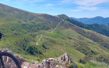
Departure from Menaggio, up Val Sanagra, via Naggio, detour to Alpe Logone, trail to Malé, hamlet of Cusino, Valcavargna. From Malé forest road to Alpe di Rozzo, mutata di Rozzo, Alpe Ailgua. Walk to the top of Mount Tabor, which is a grassy panettone 2080 meters high, shouldering the bike to the top; the descent can be done in the saddle.
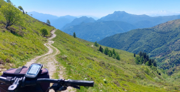
Return by the same forest road to Malè, road to Cusino, S. Bartolomeo, then Sora and the old mule track to Ponte Dovia to Carlazzo, Gottro, Rogolone trail to Codogna, former railroad bike path to Menaggio.
NOTE: The municipality of Cusino, Valcavargna, has planned a mtb trail to join Mutata di Rozzo withAlpe Nesdale with a trail of about 4 km at 1600 meters altitude. As of now, July 2025, about 1/4 of it has been done starting from the Mutata di Rozzo; the rest at the moment is not feasible even by carrying a bike, because it crosses a deep and very steep valley below the Alpe di Bellerona, where the old trail used to pass higher up. Once finished it will allow a long high route to be joined from Dongo to the S. Lucio Pass and continue with Route 66 in Ticino.
 P
P
