
 Italiano
 Deutsch
2022/10/15 09:22:47
Luzzone Dam
Author

Place
Switzerland
Km
17,35 km
Elapsed time
02:06:52
Vertical meters
+843 mt (902 - 1664)
Route difficulty
Landscapes
Last update
2022/10/16 10:51:21
Comments
Hotels
Description
We start in Olivone and climb to Campo Blenio going up the beautiful road carved into the rock.
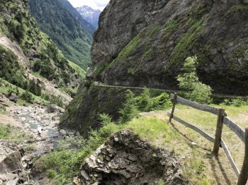
We continue to the Luzzone Dam on a paved road, pass over the dam (watch for the sport climbing route to your right) and then climb until we reach a tunnel that spits us out at Muazz Pass. From there we descend to Cumpiett and take a trail that is unfortunately initially not very cyclable despite being on level ground. There are about 15 minutes to push through.
Once in the woods the all serpentine descent to Olivone begins. Just the right amount of technique.
Local weather
Mer 00:00

18 °C
Mer 12:00

23 °C
Gio 00:00

17 °C
Gio 12:00
24 °C
Ven 00:00
19 °C
Ven 12:00
22 °C

Graph
Nearest Routes
33,95 km
Km
+1 647 mt
Vertical meters
Route difficulty
Landscapes
21,87 km
Km
+1 297 mt
Vertical meters
Route difficulty
Landscapes
73,09 km
Km
+2 560 mt
Vertical meters
Route difficulty
Landscapes
9,39 km
Km
+624 mt
Vertical meters
Route difficulty
Landscapes
39,45 km
Km
+1 721 mt
Vertical meters
Route difficulty
Landscapes
39,73 km
Km
+2 106 mt
Vertical meters
Route difficulty
Landscapes
22,11 km
Km
+580 mt
Vertical meters
Route difficulty
Landscapes
24,42 km
Km
+588 mt
Vertical meters
Route difficulty
Landscapes
56,35 km
Km
+1 850 mt
Vertical meters
Route difficulty
Landscapes
24,01 km
Km
+1 350 mt
Vertical meters
Route difficulty
Landscapes