
 Italiano
 Deutsch
Cantonill e Capanna Bovarina

This tour combines two routes from https://bleniobike.ch/tours/: the ascent and descent from Cantonill Pass and the ascent and descent from the Bovarina Hut. If this seems too long, get the tracks from the Blenio Bike website and do the one you prefer.
Start from Olivone by climbing toward the Lukmanier Pass. Shortly after Camperio you leave the pass road and take the small paved road up to Anveuda. Bucolic but rather sloping, you do it quietly while looking at the view.
Immediately after the village you take a dirt road and then a path through the grasslands. When you enter the woods you need to carry your bike for about 20 minutes to Cantonill Pass, another bucolic and very scenic place.
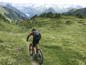
The downhill trail is very narrow and partly exposed on steep meadows, especially at the beginning you will have to push in a few sections. Then you enter the woods and it becomes easier, remaining, however, the prerogative of experienced bikers since it is rather steep and trialistic.
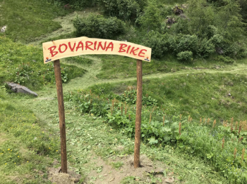
Thus you arrive below Scandorair, where the official Bovarina Bike route transits. From here it is all marked with the red mountain bike sign: it is about 600 meters of elevation gain to reach the hut, whose managers are very nice. Try the cheeses, which are fantastic! There is also place to sleep if you want to ski and enjoy the peace of the place.
The descent was prepared for mountain bikes last year, I would describe it as medium difficulty and rather flowing, except maybe a few bends.
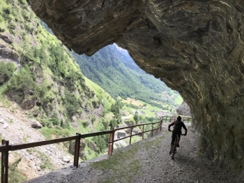
Passing through Campo Blenio, you follow the old road carved into the rock, a sort of Ticino Val d'Uina (see photo), and then resurface in Olivone.


