
 Italiano
 Deutsch
2025/05/25 12:52:20
Arosio-Gradiccioli-Gravesano
Author

Place
Switzerland
Km
28,10 km
Elapsed time
05:05:46
Vertical meters
+1 311 mt (355 - 1768)
Route difficulty
Landscapes
Last update
2025/05/25 12:52:20
Comments
Description
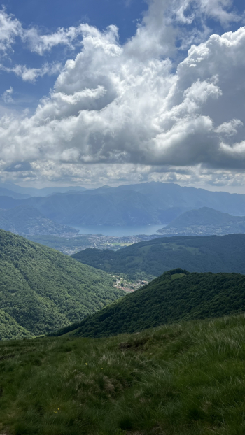
Partenza da Arosio, prima asfalto poi sentiero fino alla parte che dal Tamaro gira sotto al Gradiccioli (causa nebbia ho deciso di non salire in cima) poi fantastica discesa verso Vezio per risalire ad Arosio e poi altra discesa (semplice la prima parte, un po' tecnica la seconda) fino a Gravesano.
Panorama fantastico tra il lago di Locarno e quello di Lugano, peccato per le nebbie in quota.
Local weather

°C
°C
°C
°C
°C
°C
Graph
Nearest Routes
23,71 km
Km
+1 171 mt
Vertical meters
Route difficulty
Landscapes
59,52 km
Km
+2 228 mt
Vertical meters
Route difficulty
Landscapes
42,06 km
Km
+1 628 mt
Vertical meters
Route difficulty
Landscapes
23,27 km
Km
+979 mt
Vertical meters
Route difficulty
Landscapes
59,66 km
Km
+2 203 mt
Vertical meters
Route difficulty
Landscapes
48,08 km
Km
+1 833 mt
Vertical meters
Route difficulty
Landscapes
46,45 km
Km
+1 405 mt
Vertical meters
Route difficulty
Landscapes
20,68 km
Km
+370 mt
Vertical meters
Route difficulty
Landscapes
25,60 km
Km
+810 mt
Vertical meters
Route difficulty
Landscapes
22,53 km
Km
+388 mt
Vertical meters
Route difficulty
Landscapes