
 Italiano
 Deutsch
Monte Tamaro con discesa su Bedano

This is the third route, featuring the third descent from Monte Tamaro. You can find the first two here and here. Here’s an alternative descent from Arosio. To tell the truth, this is the official one.
The famous Monte Tamaro circuit is a classic in the Sottoceneri region of the Canton of Ticino.
The best way to do it is to buy a ticket for the cable car. The cable car runs from Easter through early November. Keep in mind that there’s usually snow on the northern side until late June. When the leaves start falling, parts of the trail can get tricky.
For the masochists, there’s a rather steep road leading from Monteceneri to Alpe Foppa, where the cable car arrives, after 1,000 meters of moderate suffering.
The problem is that the toughest part of the climb comes at the end, with 300 meters of steep, rocky elevation gain. With good leg strength and technique, you can power through it all to reach the Capanna Monte Tamaro and treat yourself to one of the delicious homemade cakes, washed down with a super-refreshing elderflower juice—also homemade.
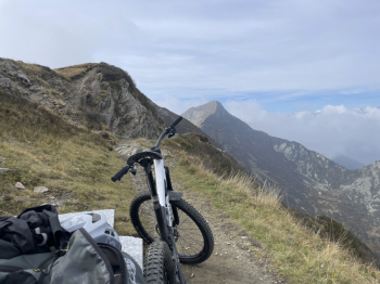
The descent is not for beginners or those who suffer from vertigo, as the initial traverse is exposed, rocky, and features technical sections not for everyone.
The same goes for the first four hairpin turns on the descent. Only once you’ve passed these challenges does the trail become smoother and easier.
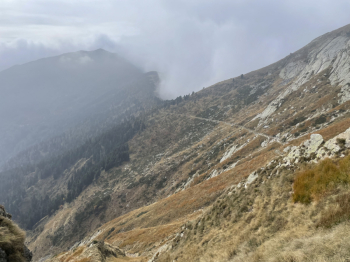
Miles and miles of radiant woodland lead us to La Bassa, where we switch sides and begin a trail that seems to have been built for bikes, but is entirely natural. Here too, you can ride the entire way, but only if you have decent riding technique.
This brings us to Arosio, where we turn left after the church and follow a road that takes us back into the woods. You’ll see that the trail initially leads you along the remains of a small track before joining the marked trail. This trail has berms, jumps, and becomes more technical as you descend, with steep and rocky sections.
You emerge onto a road, where unfortunately you’ll have to cover a few meters of elevation gain on asphalt while waiting for the trail to reach the village, since the flat sections are already there.
At the valley floor, continue on to Taverne, where there is free parking.
To reach Tamaro, follow the bike path alongside the Vedeggio.


