HOME RANKINGS CHALLENGES ROUTES NEAR ME PLANNING SEARCH LOGIN
Italy - Trentino-Alto Adige/Südtirol, BZ
2024/11/18 17:51:21

Giro delle cime di Merano 2000

130 Downloads
3
 
Share

Key Takeaways / Scheda Tecnica

Disciplina:
Mountain Bike (MTB)
Percorso:
Giro delle cime di Merano 2000
Località:
Italy - Trentino-Alto Adige/Südtirol, BZ
Distanza:
33,43 km
Dislivello Positivo:
+1 900 mt (Quota Min: 1183m - Max: 2416m)
Difficoltà Tecnica:
4/5
Valutazione Panorami:
4/5
Formato Traccia:
GPX Download disponibile
Author
nonnocarb
(324)
Place
Italy - Trentino-Alto Adige/Südtirol, BZ
Km
33,43 km
Elapsed time
03:53:04
Vertical meters
+1 900 mt (1183 - 2416)
Route difficulty
Landscapes
Last update
2024/11/18 21:54:42
Comments
0
Description


First the summit of Kuhleiten, 2361 meters, then Valcanova, 2300 meters, Mt. Catino, 2422 m and the summit of the Little Stone Men at 2000 meters.
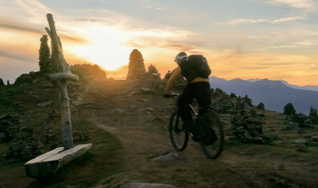
Foto itinerario MTB Giro delle cime di Merano 2000 - Italy - Trentino-Alto Adige/Südtirol, BZ

A continuous up and down ridges and trails always above 2000 meters, a super-panoramic and very technical route, ideal for experts and possibly with ebike for the steep slopes, but doable even without the little help.
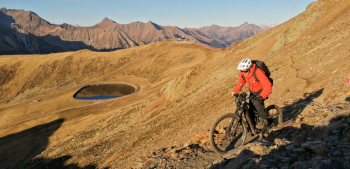
Foto itinerario MTB Giro delle cime di Merano 2000 - Italy - Trentino-Alto Adige/Südtirol, BZ

And finally down the endless and beautiful Trail 2, also called "the orgy of rocks and roots!"
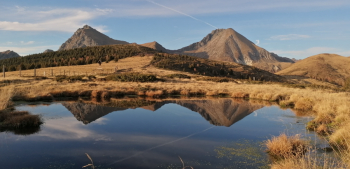
Foto itinerario MTB Giro delle cime di Merano 2000 - Italy - Trentino-Alto Adige/Südtirol, BZ

To be done with clear skies to appreciate the views!

Wonder!

Foto itinerario MTB Giro delle cime di Merano 2000 - Italy - Trentino-Alto Adige/Südtirol, BZ

Download our free mobile app to send this route to your Garmin device or to navigate it on OSM maps. Android - iOS
Local weather
Mar 00:00
10 °C
Mar 12:00
11 °C
Mer 00:00
10 °C
Mer 12:00
11 °C
Gio 00:00
6 °C
Gio 12:00
8 °C
Ven 00:00
4 °C
Ven 12:00
6 °C
Sab 00:00
5 °C
Sab 12:00
5 °C

Graph

Nearest Routes

2023/02/26
- Italy - Trentino-Alto Adige/Südtirol, BZ
nonnocarb
(324)
32,06 km
Km
+1 368 mt
Vertical meters
Route difficulty
Landscapes
2024/07/05
- Italy - Trentino-Alto Adige/Südtirol, BZ
nonnocarb
(324)
43,61 km
Km
+1 800 mt
Vertical meters
Route difficulty
Landscapes
2023/02/26
- Italy - Trentino-Alto Adige/Südtirol, BZ
nonnocarb
(324)
28,26 km
Km
+1 190 mt
Vertical meters
Route difficulty
Landscapes
2023/02/26
- Italy - Trentino-Alto Adige/Südtirol, BZ
nonnocarb
(324)
20,39 km
Km
+570 mt
Vertical meters
Route difficulty
Landscapes
2022/10/22
- Italy - Trentino-Alto Adige/Südtirol, BZ
nonnocarb
(324)
35,34 km
Km
+1 823 mt
Vertical meters
Route difficulty
Landscapes
2023/02/26
- Italy - Trentino-Alto Adige/Südtirol, BZ
nonnocarb
(324)
37,88 km
Km
+1 630 mt
Vertical meters
Route difficulty
Landscapes
2023/02/26
- Italy - Trentino-Alto Adige/Südtirol, BZ
nonnocarb
(324)
12,81 km
Km
+785 mt
Vertical meters
Route difficulty
Landscapes
2023/02/26
- Italy - Trentino-Alto Adige/Südtirol, BZ
nonnocarb
(324)
57,25 km
Km
+1 750 mt
Vertical meters
Route difficulty
Landscapes
2023/02/26
- Italy - Trentino-Alto Adige/Südtirol, BZ
nonnocarb
(324)
32,64 km
Km
+1 230 mt
Vertical meters
Route difficulty
Landscapes
2023/03/04
- Italy - Trentino-Alto Adige/Südtirol, BZ
nonnocarb
(324)
86,35 km
Km
+1 800 mt
Vertical meters
Route difficulty
Landscapes

0 Comments