HOME RANKINGS CHALLENGES ROUTES POI PLANNING SEARCH LOGIN
Italy - Trentino-Alto Adige/Südtirol, BZ
2023/02/26 18:08:13

Al rifugio Kuhleiten sulla neve

2 Downloads
1
 
Author
nonnocarb
(266)
Place
Italy - Trentino-Alto Adige/Südtirol, BZ
Km
28,26 km
Elapsed time
03:44:57
Vertical meters
+1 190 mt (1239 - 2358)
Route difficulty
Landscapes
Last update
2023/12/04 13:46:12
Comments
0
Description

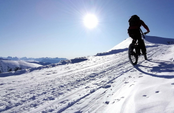
Winter route, to be done only with #old and well groomed snow, ideal for ebikes with plus tires, but also doable without engine, better if with fat bike, providing however more pushing sections. Doable and very beautiful even in summer with slight detours, however marked with signs.

From the parking lot at the carabinieri station in Hafling, go up on asphalt to Falzeben. From here on snowy forest road with steep but rideable sections to Weidmann hut (refreshment). You then climb up to ref Kuhleiten, with very hard sections, surmountable by ebike only if the snow is very compact. You only push on a very steep 20 m section. By fat bike, however, much longer pushing sections.

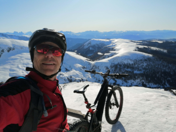
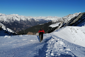
From ref Kuhleiten (refreshment) incredible views of the dolomites and the alps. Descent then to the Merano ref (refreshment) and then go along the European trail to the yoke of the cross, with amazing views. (only with old, well-beaten snow). All pedaled by ebike, 15 min push by fat bike.

Turn back, descend to Maia hut with very fun descent, then to Falzeben. Turn left downhill into the woods and back to the parking lot with one last stretch on asphalt.

Download our free mobile app to send this route to your Garmin device or to navigate it on OSM maps. Android - iOS

Graph

Nearest Routes

2023/02/26
- Italy - Trentino-Alto Adige/Südtirol, BZ
nonnocarb
(266)
32,06 km
Km
+1 368 mt
Vertical meters
Route difficulty
Landscapes
2022/10/22
- Italy - Trentino-Alto Adige/Südtirol, BZ
nonnocarb
(266)
35,34 km
Km
+1 823 mt
Vertical meters
Route difficulty
Landscapes
2023/02/26
- Italy - Trentino-Alto Adige/Südtirol, BZ
nonnocarb
(266)
20,39 km
Km
+570 mt
Vertical meters
Route difficulty
Landscapes
2023/02/26
- Italy - Trentino-Alto Adige/Südtirol, BZ
nonnocarb
(266)
37,88 km
Km
+1 630 mt
Vertical meters
Route difficulty
Landscapes
2023/02/26
- Italy - Trentino-Alto Adige/Südtirol, BZ
nonnocarb
(266)
12,81 km
Km
+785 mt
Vertical meters
Route difficulty
Landscapes
2023/02/26
- Italy - Trentino-Alto Adige/Südtirol, BZ
nonnocarb
(266)
57,25 km
Km
+1 750 mt
Vertical meters
Route difficulty
Landscapes
2023/02/26
- Italy - Trentino-Alto Adige/Südtirol, BZ
nonnocarb
(266)
32,64 km
Km
+1 230 mt
Vertical meters
Route difficulty
Landscapes
2023/03/04
- Italy - Trentino-Alto Adige/Südtirol, BZ
nonnocarb
(266)
86,35 km
Km
+1 800 mt
Vertical meters
Route difficulty
Landscapes
2023/03/06
- Italy - Trentino-Alto Adige/Südtirol, BZ
nonnocarb
(266)
31,04 km
Km
+1 800 mt
Vertical meters
Route difficulty
Landscapes
2023/02/26
- Italy - Trentino-Alto Adige/Südtirol, BZ
nonnocarb
(266)
17,24 km
Km
+630 mt
Vertical meters
Route difficulty
Landscapes

0 Comments