HOME RANKINGS CHALLENGES ROUTES NEAR ME PLANNING SEARCH LOGIN
Italy - Trentino-Alto Adige/Südtirol, TN
2024/07/21 07:45:29

Monte Agnello

9 Downloads
0
 
Share
Author
marco
(152)
Place
Italy - Trentino-Alto Adige/Südtirol, TN
Km
21,06 km
Elapsed time
03:03:59
Vertical meters
+530 mt (962 - 2217)
Route difficulty
Landscapes
Last update
2025/07/15 22:55:10
Comments
0
Description

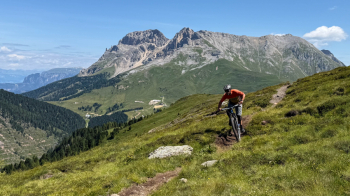
We climb to Alpe di Pampeago taking advantage of two lifts, a cable car and a chairlift, starting just outside Predazzo. We quickly descend on dirt road then climb a steep ramp to a restaurant. Immediately after that we take a nice easy traverse (watch out for pedestrians) that brings us to the beginning of the trail that will soon go uphill, not steep and totally rideable.

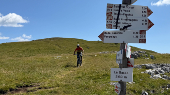
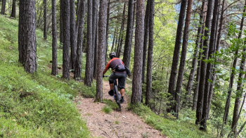
We then start to descend following 3 trails: the 513 which presents no difficulties except for the first 30 meters; the 514 also nice and smooth and the 510, definitely much more challenging that follows the course of the Rivo Bianco, the trail presents various difficulties, narrows, steps, exposed sections, tight hairpin bends, there are also two short sections with steel cable that are passed on foot without problems. When we get to the dirt road (if you don't want to pedal uphill go straight downhill and then take the bike path back to Predazzo) we cross the creek and briefly push the bike uphill, after which we pedal up and down passing a cliff. We push the bike uphill again and then begin a descent into the woods, very nice but with some technical passages. We come to a fork and, as before, we continue downhill if we don't want to pedal more uphill.

In fact, the trail continues to the left on a challenging uphill and false-flat path (Coronelle scenic trail), which will start descending to intersect with a dirt road. We cross it and take the nice trail into the valley, with some technical switchbacks but also several smooth sections. We are in Ziano di Fiemme, take the bike path (the trail makes an excursion into downtown Predazzo to eat a sandwich) and return to the starting point.

Download our free mobile app to send this route to your Garmin device or to navigate it on OSM maps. Android - iOS
Local weather
°C
°C
°C
°C
°C
°C
°C
°C
°C
°C

Graph

Nearest Routes

2023/02/26
- Italy - Trentino-Alto Adige/Südtirol, BZ
nonnocarb
(294)
38,74 km
Km
+1 130 mt
Vertical meters
Route difficulty
Landscapes
2022/08/03
- Italy - Trentino-Alto Adige/Südtirol, BZ
steve-U
(24)
26,36 km
Km
+1 245 mt
Vertical meters
Route difficulty
Landscapes
2023/02/26
- Italy - Trentino-Alto Adige/Südtirol, BZ
nonnocarb
(294)
21,93 km
Km
+1 002 mt
Vertical meters
Route difficulty
Landscapes
2023/02/06
- Italy - Trentino-Alto Adige/Südtirol, BZ
nonnocarb
(294)
35,36 km
Km
+1 065 mt
Vertical meters
Route difficulty
Landscapes
2023/07/27
- Italy - Trentino-Alto Adige/Südtirol, TN
steve-U
(24)
31,96 km
Km
+2 156 mt
Vertical meters
Route difficulty
Landscapes
2023/02/26
- Italy - Trentino-Alto Adige/Südtirol, BZ
nonnocarb
(294)
39,56 km
Km
+1 700 mt
Vertical meters
Route difficulty
Landscapes
2023/02/26
- Italy - Trentino-Alto Adige/Südtirol, BZ
nonnocarb
(294)
33,67 km
Km
+1 230 mt
Vertical meters
Route difficulty
Landscapes
2022/10/09
- Italy - Trentino-Alto Adige/Südtirol, TN
marco
(152)
34,48 km
Km
+1 457 mt
Vertical meters
Route difficulty
Landscapes
2023/08/29
- Italy - Trentino-Alto Adige/Südtirol, TN
Scc
(3)
47,89 km
Km
+2 166 mt
Vertical meters
Route difficulty
Landscapes
2022/11/19
- Italy - Trentino-Alto Adige/Südtirol, TN
58,20 km
Km
+3 100 mt
Vertical meters
Route difficulty
Landscapes

0 Comments