HOME RANKINGS CHALLENGES ROUTES NEAR ME PLANNING SEARCH LOGIN
Switzerland
2023/11/28 20:42:11

Airolo tour

14 Downloads
3
 
Share
Author
Olerbiker
(9)
Place
Switzerland
Km
46,43 km
Elapsed time
06:37:03
Vertical meters
+1 930 mt (1145 - 2121)
Route difficulty
Landscapes
Last update
2023/11/28 21:20:52
Comments
2
Description

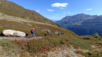
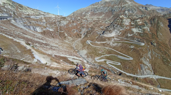
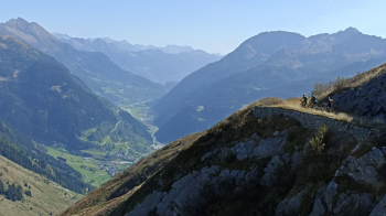
Departing from the convenient and large parking lot of the cable car that serves the bike-park ( or ski slopes ), you descend toward the village until you take the ascent of the Tremola valley, which is always fascinating; having reached the St. Gotthard pass, you must go to cross the big road, to take the dirt road that skirts the last section of the road covered uphill from Airolo. This is a quasi-mule track that leads to join, via a short push section, the Banchi-weg, a beautiful scenic path, comfortable and never difficult, but with very exposed sections. From this you enter the Bedretto valley on the high road, a dirt road a few km long with views towards Nufenenpass, Gries and various peaks in the area, well known to ski mountaineers/climbers etc., (great environment) you follow it to the entrance of a splendid singletrack that will lead in 600m of elevation gain, between rocky-edged passages (watch out for derailleurs!), some steep and a pine needle forest with a few exposed S3 hairpin bends, to the village of Bedretto. From here we ascend to take the Alpi road that leads us, in still beautiful surroundings, to the village of Pescium where some descents of the bike-park start. Our choice was for Bosco trail variant + Runcasc. The ride was done with e-mtb on 7/10/2023.
Download our free mobile app to send this route to your Garmin device or to navigate it on OSM maps. Android - iOS
Local weather
Today
0 °C
Tonight
-1 °C
Tomorrow
1 °C
Tomorrow night
-8 °C
Sunday
-3 °C
Sunday night
-7 °C
Monday
2 °C
Monday night
-3 °C
Tuesday
5 °C
Tuesday night
1 °C

Graph

Nearest Routes

2023/02/25
- Switzerland
marco
(135)
99,40 km
Km
+2 901 mt
Vertical meters
Route difficulty
Landscapes
2023/04/06
- Switzerland
29,12 km
Km
+1 109 mt
Vertical meters
Route difficulty
Landscapes
2022/08/22
- Switzerland
marco
(135)
52,87 km
Km
+2 035 mt
Vertical meters
Route difficulty
Landscapes
2022/10/15
- Switzerland
marco
(135)
30,39 km
Km
+1 182 mt
Vertical meters
Route difficulty
Landscapes
2024/08/06
- Switzerland
marco
(135)
28,98 km
Km
+1 362 mt
Vertical meters
Route difficulty
Landscapes
2024/10/30
- Switzerland
marco
(135)
21,53 km
Km
+1 135 mt
Vertical meters
Route difficulty
Landscapes
37,05 km
Km
+1 654 mt
Vertical meters
Route difficulty
Landscapes
2022/09/17
- Switzerland
marco
(135)
20,86 km
Km
+1 186 mt
Vertical meters
Route difficulty
Landscapes
2022/08/18
- Switzerland
marco
(135)
24,42 km
Km
+588 mt
Vertical meters
Route difficulty
Landscapes
2022/12/20
- Switzerland
marco
(135)
39,91 km
Km
+1 350 mt
Vertical meters
Route difficulty
Landscapes

2 Comments