HOME RANKINGS CHALLENGES ROUTES POI PLANNING SEARCH LOGIN
Italy - Trentino-Alto Adige/Südtirol, BZ
2023/09/17 12:28:14

Monte Pascolo e Lago Rodella

2 Downloads
0
 
Author
Robibz
(19)
Place
Italy - Trentino-Alto Adige/Südtirol, BZ
Km
32,99 km
Elapsed time
08:09:29
Vertical meters
+1 848 mt (779 - 2374)
Route difficulty
Landscapes
Last update
2023/09/17 16:56:33
Comments
0
Description

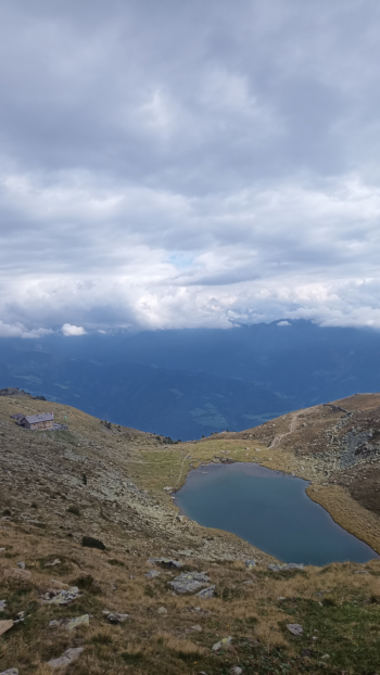
Beautiful and very strenuous all-mountain tour leading up to Lake Rodella and the summit of Monte Pascolo. You leave your car at the parking lot of the sports field before you get to the village of Velturno, from here you climb first by road and then by forest to Lake Rodella, in this first part you do about 1450 meters of elevation gain in 14.5 km. In the last part you have to push and shoulder the bike for some stretches. Once you get to the lake you can refresh yourself at the Rodella refuge.

From the refuge you start again and do about 170 meters of bike backpacking to reach the summit of Monte Pascolo.

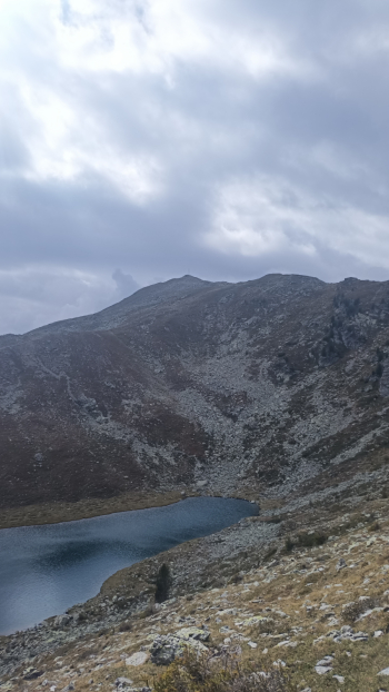
From the summit starts the first of the two descents of this beautiful tour. This is the toughest descent in a purely alpine environment, with some very technical sections and some during which you have to push the bike, I would say we are on the difficult S3. Unfortunately the weather was not on our side yesterday, but in good weather you can see the Odle, Plose, Sciliar and Sas de Putia:

Once we get down we skirt the ridge until we get back to the trail that took us to Lake Rodella, the first part is very smooth and rideable, in the second part we have to do about 120 meters of bike backpacking. Finished this part begins the second descent, definitely easier and more fun, as a nice S2 not too easy nor too difficult.

Download our free mobile app to send this route to your Garmin device or to navigate it on OSM maps. Android - iOS

Graph

Nearest Routes

2023/03/06
- Italy - Trentino-Alto Adige/Südtirol, BZ
nonnocarb
(266)
50,29 km
Km
+1 600 mt
Vertical meters
Route difficulty
Landscapes
2023/03/07
- Italy - Trentino-Alto Adige/Südtirol, BZ
nonnocarb
(266)
52,68 km
Km
+1 700 mt
Vertical meters
Route difficulty
Landscapes
2023/03/04
- Italy - Trentino-Alto Adige/Südtirol, BZ
nonnocarb
(266)
67,92 km
Km
+2 220 mt
Vertical meters
Route difficulty
Landscapes
2023/10/20
- Italy - Trentino-Alto Adige/Südtirol, BZ
Scc
(2)
48,02 km
Km
+2 588 mt
Vertical meters
Route difficulty
Landscapes
2023/03/04
- Italy - Trentino-Alto Adige/Südtirol, BZ
giobike73
(49)
54,04 km
Km
+1 320 mt
Vertical meters
Route difficulty
Landscapes
2022/09/19
- Italy - Trentino-Alto Adige/Südtirol, BZ
37,99 km
Km
+1 851 mt
Vertical meters
Route difficulty
Landscapes
2022/10/30
- Italy - Trentino-Alto Adige/Südtirol, BZ
nonnocarb
(266)
80,29 km
Km
+2 211 mt
Vertical meters
Route difficulty
Landscapes
2023/03/07
- Italy - Trentino-Alto Adige/Südtirol, BZ
nonnocarb
(266)
36,18 km
Km
+1 590 mt
Vertical meters
Route difficulty
Landscapes
2023/02/16
- Italy - Trentino-Alto Adige/Südtirol, BZ
nonnocarb
(266)
34,35 km
Km
+1 288 mt
Vertical meters
Route difficulty
Landscapes
2024/02/02
- Italy - Trentino-Alto Adige/Südtirol, BZ
nonnocarb
(266)
36,85 km
Km
+1 250 mt
Vertical meters
Route difficulty
Landscapes

0 Comments