HOME RANKINGS CHALLENGES ROUTES POI PLANNING SEARCH LOGIN
Italy - Lombardia, BS
2023/09/11 08:39:09

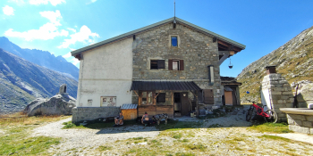
Rifugio Prudenzini e la Val Salarno

42 Downloads
0
 
Author
Giulien
(110)
Place
Italy - Lombardia, BS
Km
31,89 km
Elapsed time
05:46:24
Vertical meters
+1 447 mt (1096 - 2271)
Route difficulty
Landscapes
Last update
2023/09/11 18:17:42
Comments
0
Description

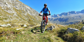
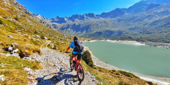
Let us discover together the Salarno Valley where you will find yourself transported to a wonderful high-altitude environment. Lake Salarno is a gem set in the heart of this valley with a refuge, the Prudenzini, where you can stop before the descent.
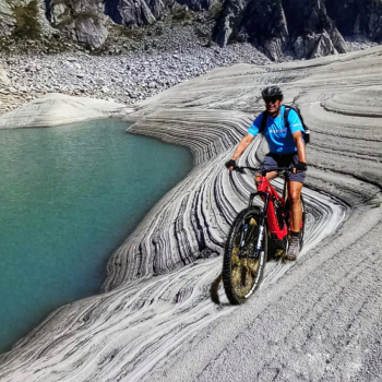
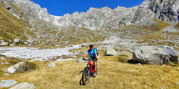
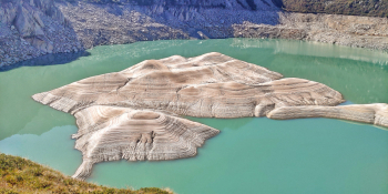
We reach the village of Cevo (BS) in Val Saviore in the presence of Piz Olda and through a nice undergrowth trail we move toward Saviore dell'Adamello where the narrow paved road to the Prudenzini basically starts. Upon reaching Fabrezza the going gets challenging. The climb literally changes gradient and becomes a mule track with cemented and then stony sections. The views will immediately be spectacular and you will be enraptured by the beauty of this place. At about 2,000 meters you will come out in front of the magnificent Lake Salarno where at this time the sandy deposits make it absolutely more fascinating than usual. Next you will admire Lake Dossaccio fed, like the previous one, by Salarno's Poia Torrent. Here guys the beauty multiplies and all the way to the Prudenzini Refuge you will feel like you are in a movie. We continue past the refuge to go and admire the ruins of the former Alpini shelter destroyed by an avalanche. This will be the first point of return to the hut, where you can at this point stop to regain your strength.

Let's get ready for the descent, which will be immediately technical on very large stones with challenging passages. This is a short piece because then we will return directly to the mule track traveled on the outward journey where we will pay close attention to people going up and to the boulder-strewn sections where we can float the bike, with no particular difficulty. Once we reach Saviore we will ride towards the pine forest of Cevo.

RECOMMENDED ROUTE FOR MOUNTAIN BIKE and/or E-BIKE ALL MOUNTAIN.

NB: At the time of entry this ride is all doable without any particular problems. We disclaim any responsibility for any inconvenience due to lack of maintenance of the trails or deterioration of the same due to external and/or natural agents and a wrong assessment of the tour.


Download our free mobile app to send this route to your Garmin device or to navigate it on OSM maps. Android - iOS

Graph

Nearest Routes

2022/09/22
- Italy - Lombardia, BS
14,28 km
Km
+844 mt
Vertical meters
Route difficulty
Landscapes
2022/12/09
- Italy - Lombardia, BS
23,11 km
Km
+1 433 mt
Vertical meters
Route difficulty
Landscapes
2023/10/03
- Italy - Lombardia, BS
giannig
(17)
32,38 km
Km
+1 800 mt
Vertical meters
Route difficulty
Landscapes
2022/09/20
- Italy - Lombardia, BS
22,36 km
Km
+1 357 mt
Vertical meters
Route difficulty
Landscapes
2023/10/30
- Italy - Lombardia, BS
Giulien
(110)
37,49 km
Km
+2 100 mt
Vertical meters
Route difficulty
Landscapes
2022/09/22
- Italy - Lombardia, BS
35,87 km
Km
+1 835 mt
Vertical meters
Route difficulty
Landscapes
2022/09/07
- Italy - Lombardia, BS
giannig
(17)
16,40 km
Km
+1 300 mt
Vertical meters
Route difficulty
Landscapes
2023/12/25
- Italy - Lombardia, BS
Padagiant
(8)
20,55 km
Km
+1 300 mt
Vertical meters
Route difficulty
Landscapes
2022/09/08
- Italy - Lombardia, BS
Giulien
(110)
23,15 km
Km
+1 511 mt
Vertical meters
Route difficulty
Landscapes
2022/09/08
- Italy - Lombardia, BS
Giulien
(110)
23,51 km
Km
+1 519 mt
Vertical meters
Route difficulty
Landscapes

0 Comments