HOME RANKINGS CHALLENGES ROUTES POI PLANNING SEARCH LOGIN
Italy - Trentino-Alto Adige/Südtirol, BZ
2023/09/01 16:36:41

Cornetto di Confine

7 Downloads
0
 
Author
Place
Italy - Trentino-Alto Adige/Südtirol, BZ
Km
47,62 km
Elapsed time
06:45:14
Vertical meters
+1 550 mt (1169 - 2527)
Route difficulty
Landscapes
Last update
2023/09/01 17:04:11
Comments
0
Description

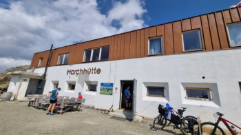
After 18 years we return to this peak on the Italian-Austrian border finding two nice new features. The first: a refuge there where the abandoned barracks used to be (open since 2021).

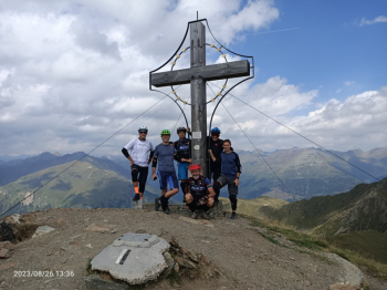
The second: the cross on the summit.

This time we set off from San Candido and arrived in Dobbiaco and climbed the slopes of the Innicher Eck where before the summit (1900m) we found the Lachwiesen hut (1690m).

From the crossroads reached after a short descent we have 8 km of ascent for 700 meters of elevation gain, at 2290m at the seventh hairpin bend there is a providential fountain.

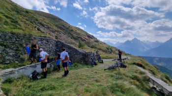
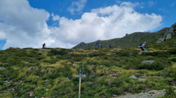
Reaching the top we continue on the dirt road that follows the boundary line for a few km to the barracks below the Pausa Alta (Hochrast), from here the path 3a branches off downhill and descends sinuously through the meadows without excessive technical difficulties, stones and steps being the main feature.

You intersect a first dirt road and continue left to the new trail entrance (no bikes allowed, those who do not want to do this section can continue on the dirt road), this segment is more challenging than the previous one because of the narrow width with gullies and vegetation encroaching on the trail in places.

At an altitude of 1900m we find a dirt road, later paved, which we take downhill to Prato alla Drava. The return to San Candido takes place following the famous Val Pusteria bicycle path.

Download our free mobile app to send this route to your Garmin device or to navigate it on OSM maps. Android - iOS

Graph

Nearest Routes

2023/03/02
- Italy - Trentino-Alto Adige/Südtirol, BZ
civi65
(100)
43,07 km
Km
+1 550 mt
Vertical meters
Route difficulty
Landscapes
2023/03/01
- Italy - Trentino-Alto Adige/Südtirol, BZ
nonnocarb
(266)
135,06 km
Km
+3 800 mt
Vertical meters
Route difficulty
Landscapes
2023/03/08
- Italy - Trentino-Alto Adige/Südtirol, BZ
Antosangui
(106)
21,33 km
Km
+702 mt
Vertical meters
Route difficulty
Landscapes
2023/02/26
- Italy - Trentino-Alto Adige/Südtirol, BZ
nonnocarb
(266)
26,73 km
Km
+300 mt
Vertical meters
Route difficulty
Landscapes
2023/08/26
- Italy - Trentino-Alto Adige/Südtirol, BZ
Antosangui
(106)
34,13 km
Km
+1 290 mt
Vertical meters
Route difficulty
Landscapes
2023/03/02
- Italy - Trentino-Alto Adige/Südtirol, BZ
Antosangui
(106)
50,14 km
Km
+1 016 mt
Vertical meters
Route difficulty
Landscapes
2023/02/25
- Italy - Trentino-Alto Adige/Südtirol, BZ
Antosangui
(106)
43,92 km
Km
+1 487 mt
Vertical meters
Route difficulty
Landscapes
2023/03/02
- Italy - Trentino-Alto Adige/Südtirol, BZ
Antosangui
(106)
48,67 km
Km
+213 mt
Vertical meters
Route difficulty
Landscapes
2023/02/25
- Italy - Trentino-Alto Adige/Südtirol, BZ
Antosangui
(106)
41,26 km
Km
+1 406 mt
Vertical meters
Route difficulty
Landscapes
2023/08/26
- Italy - Trentino-Alto Adige/Südtirol, BZ
Antosangui
(106)
77,84 km
Km
+2 510 mt
Vertical meters
Route difficulty
Landscapes

0 Comments