
 Italiano
 Deutsch
Tour des Combins
There are different schools of thought regarding the Tour Des Combins trail to be tackled by bike; this one has the distinction of reaching the 3347 meters above sea level of Mont Avril and ascending to the Great St. Bernard Pass from the unprecedented Col des Chevaux to give you the same feeling as Napoleon Bonaparte (portrayed by Jacques-Louis David in the very famous painting "Bonaparte Crosses the Alps") who passed over with the army he led to win the second Italian campaign. You will feel equally victorious riding your steel (or aluminum, or titanium, whatever) steeds. With carbon a little less victorious, more fibrous I would say.

Stage 1: Champillon - Cabane de Chanrion
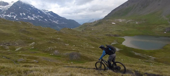
We leave the car at the picnic area in Doues, Champillon locality, at an altitude of 2060 meters, and start pedaling on the flat Ru de By for about 8 km, with views of the Grand Combin, the Grand Gelé, and our summit, Mont Avril. A narrow passage between rocks will force us to disassemble the front wheel of the bikes, but the important thing is to have the allen wrench in the pivot! And above all, don't drop anything in the grid that separates you from the ru, on pain of finishing the other 110km with a stick instead of a wheel axle. Just don't do it.

A short descent brings us to the Conca di By where we take the comfortable forest road that climbs up to the Fenêtre de Durand, but we will pedal all in all for a short time; in fact, past the pasture of Thoules, the trail begins to climb and 400 meters will await us by pushing or by bike on our backs up to the 2800 meters of the window, made pleasant by the passage near several small lakes fed by the snowmelt.

A border marker will inform you that you are in Switzerland (perhaps TIM/Vodafone will inform you first with the usual cell phone message, watch out for mobile data). If you find wind, at Fenêtre de Durand, do not be frightened, it is normal, and the weather changes very quickly here. The ascent to Avril leaves no room for half-measures, up the bike on the shoulders, down the gargoyle bar, 500 meters of shouldering await us to reach an incedible balcony on the Glacier du Mont Durand. No summit cross, just 2 crosses carved into the hard stone, and painted red, will mark the boundary for you. You can now brag to your friends at the bar that you have reached 3347 meters in Italy and soon after in Switzerland, or vice versa.
Look at the Combin. Now turn 90 degrees to the right. There, the little one there at the bottom, with mirrored panels reflecting the sun as if it wanted to blind you, is the Cabane we aim to get to by evening. By 6:30 p.m. to be precise, dinner (le souper) is inflexibly served at that time, we are in Switzerland!
Descent mode: all the way down to the Fenêtre you will feel like you've gone back 6 months, it's practically like skiing down the snow. Fun to the madness! Glided back over the boundary marker (maybe not right on top, it's been there for 90 years) now all that's left is to descend the Swiss side, on a smooth but fun singletrack that quickly takes us to an altitude of 2200, where we intercept the forestry road that climbs about 250 meters up to the Cabane de Chanrion (what a box, a ride that ends uphill, let's hope it doesn't become a habit. NB: The Cabane de Chanrion, despite having a large dormitory, is very popular and you'll have to book on the Club Alpin Suisse website months in advance to find a place, otherwise... bring your tent.
Stage 2: Cabane de Chanrion - Bourg-Saint-Pierre.
This is the most pedaled stage of the tour, but wait to crow about it! Leaving the hut (they will offer to make you breakfast from 4 a.m. onward, you judge how much you want to hurt yourself) we briefly climb the dirt road to find ourselves pushing and pulling chains on the trail that takes us to the Col de Tsofeiret. Here, assuming you have not overindulged on the fennel-seed salami from the hut, you may begin to spot ibex and various marmots. Otherwise, showing up at the col to the sound of burping will only help you ward off all sorts of local wildlife, including the Austrian tourists you met the night before at the refuge.
A nice idyllic but boulder-strewn path that might force you to retire your bike's derailleur early leads us in sight of Lac de Mauvoisin, one of the largest reservoirs in Switzerland. If you want to be cool the night before with the Austrians, "dam" is called "barrage," and it rhymes with "marriage" because yes, back home your wife is waiting for you with divorce papers ready!

We skirt the lake for a few kilometers, crossing some tunnels (no need for lights, anyway, the long ones are lit) and passing under several roars of water (stay to the right) until we reach the "barrage" just now. Some cuts, some false plateaus (very false), lead us in short (I mean, since we left the hut it has already been almost 4 hours) to the small village of Fionnay, where you will find a fountain to fill your water bottles. Pedaled moment of the tour: initially on asphalt and then on easy dirt road, with some ups and downs in the woods, we arrive at the Alpage de Mille, just below the Col de Mille, where the Cabane de Mille stands. From the Alpage to the col you can very well push on, a few stretches will almost convince you that you can make it in the saddle, but still nothing transcendental. At the refuge, cake and coke await us, moving views of the Mont Blanc and Combins massifs, and briefing for the descent.

In lieu of the dirt track included in other routes, we decide to try the very smooth Alpage Druges trail, which quickly takes us back to the valley. Today also ends uphill, still having to gain those 150 meters of elevation gain that separate us from the stage post, but fortunately some improvised variant avoids us from doing the busy asphalt tongue.
Stage 3: Bourg-Saint-Pierre - Champillon
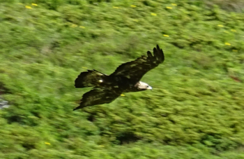
The triumphant stage! Leaving Bourg we avoid asphalt like the plague by taking the old Great St. Bernard Pass road, arriving in front of the Lac de Toules dam. On a dirt road we reach the highest level of the dam and then begin a nice singletrack that skirts the entire lake with some up and down. Once the lake is over, the pedaling part ends for a while, but to climb up to Col des Chevaux an idyllic little valley awaits us that will make us forget all the suffering. Just us and the eagles hunting marmots.
The creek that we will cross several times will allow us to keep fresh and clear-headed given the 700 meters of shouldering that await us, without penalty discount. The trail is landslide in places, but the military-type matrix is well recognized, with never excessive slopes and easy switchbacks. Here we get a stunning view of Mont Blanc on one side and Combin and Velan Mountain on the other when we reach the top. Sandwich moment, at the exact spot where Bonaparte did the same 200-odd years earlier, because anyone who doesn't eat a sandwich in company is not a son of Mary.
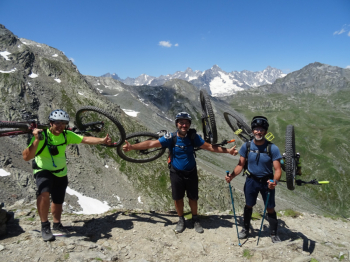
Having taken the ritual photos, the descent begins (or ascent to the slightly higher hillside for poser photos and videos).


A descent that is at times smooth, at times really hardcore and technical, will hold your breath (and killer views of the surrounding 4000s) until you land in Riccione, er yes in short, at the Great St. Bernard Pass. A hellish bedlam of people who have come from everywhere in cars and crackling motorcycles will give you goosebumps and the instinct to escape from such hell as soon as possible. But the urge to have a coke will win out, I'll give you that one. There is also, on the Italian side of the lake, a very cool fountain where you can fill your water bottles. Back in the beautiful village, the TDC (Tour des Combins) signs begin again, which we will follow almost to the letter (follow the trail if you don't want to shoot yourself dozens of extra meters of elevation gain to get back to the car).
After a short descent a very long stretch of depressurization will begin along a flat singletrack on the midslope, which will only make us smell the smoked ham from Saint Rhemy-en-Bosses; reaching it will be easier at the supermarket in Aosta than here. Several ups and downs lead us to the day's wild card, a fierce shoulder climb of a hundred meters in the woods, very steep, to avoid going too far down and conserve potential energy.
At the end of the fair, after several kilometers of up and down ru, the triumphant moment along (and it could not have been otherwise given the Napoleonic imprint of the day) the Ru Bridleway. 300 meters of all-pedal climb finally brings us back to the car, and that makes 3 out of 3 days ending uphill! But what a sight to get to the car and see the Combin lit pink again by the sharp rays of the sunset, romantic moment and bath in the fountain of the picnic area can only leave us satisfied with this great adventure!


