HOME RANKINGS CHALLENGES ROUTES NEAR ME PLANNING SEARCH LOGIN
Switzerland
2022/09/17 19:05:34

Lago Tremorgio

15 Downloads
1
 
Share

Key Takeaways / Scheda Tecnica

Disciplina:
Mountain Bike (MTB)
Percorso:
Lago Tremorgio
Località:
Switzerland
Distanza:
20,86 km
Dislivello Positivo:
+1 186 mt (Quota Min: 960m - Max: 2084m)
Difficoltà Tecnica:
4/5
Valutazione Panorami:
3/5
Formato Traccia:
GPX Download disponibile
Author
marco
(195)
Place
Switzerland
Km
20,86 km
Elapsed time
02:57:17
Vertical meters
+1 186 mt (960 - 2084)
Route difficulty
Landscapes
Last update
2025/10/13 21:39:05
Comments
0
Description

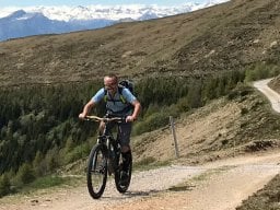
Tour to beautiful Lake Tremorgio, high above the Leventina Valley. We start from the parking lot of the cable car that leads right to the lake and climb toward Dalpe. The dirt road is never very steep except for its final part, which is also quite rocky, to get to the Venit Pass, where you will see the lake further down. Without ebike it is 270 meters of elevation gain by pushing, with ebike you do most of it in the saddle, I think. There are technical points that can be fun.

Foto itinerario MTB Lago Tremorgio - Switzerland

The first part of the descent to the lake was easy, now it has several dug-out spots.

Foto itinerario MTB Lago Tremorgio - Switzerland

We go around the lake to get to the top station of the cable car, where there is also the Tremorgio Hut (refreshment).

Foto itinerario MTB Lago Tremorgio - Switzerland

From here the trail gets pretty tough, with some challenging sections, especially at the top. The further down you go, the easier it becomes, until you get back to the starting point.

Download our free mobile app to send this route to your Garmin device or to navigate it on OSM maps. Android - iOS
Local weather
Mar 00:00
11 °C
Mar 12:00
11 °C
Mer 00:00
10 °C
Mer 12:00
11 °C
Gio 00:00
7 °C
Gio 12:00
10 °C
Ven 00:00
7 °C
Ven 12:00
5 °C
Sab 00:00
5 °C
Sab 12:00
8 °C

Graph

Nearest Routes

2025/10/13
- Switzerland
marco
(195)
24,01 km
Km
+1 350 mt
Vertical meters
Route difficulty
Landscapes
42,24 km
Km
+1 520 mt
Vertical meters
Route difficulty
Landscapes
2022/08/18
- Switzerland
marco
(195)
24,42 km
Km
+588 mt
Vertical meters
Route difficulty
Landscapes
2023/04/06
- Switzerland
29,12 km
Km
+1 109 mt
Vertical meters
Route difficulty
Landscapes
2023/02/25
- Switzerland
marco
(195)
99,40 km
Km
+2 901 mt
Vertical meters
Route difficulty
Landscapes
2025/07/31
- Switzerland
marco
(195)
41,34 km
Km
+1 587 mt
Vertical meters
Route difficulty
Landscapes
2023/11/28
- Switzerland
Olerbiker
(10)
46,43 km
Km
+1 930 mt
Vertical meters
Route difficulty
Landscapes
2024/08/25
- Switzerland
marco
(195)
73,09 km
Km
+2 560 mt
Vertical meters
Route difficulty
Landscapes
2024/06/22
- Switzerland
marco
(195)
21,87 km
Km
+1 297 mt
Vertical meters
Route difficulty
Landscapes
2024/06/22
- Switzerland
marco
(195)
9,39 km
Km
+624 mt
Vertical meters
Route difficulty
Landscapes

0 Comments