Italiano
 Deutsch
Monte Nebin 2.514 m. - Val Maira - giro ad anello da Stroppo

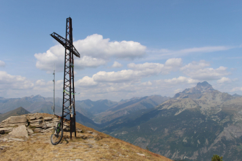
Great hike in the Maira Valley, the second published after Monte Bellino. The climb is mostly on asphalt, 1200 meters of elevation gain in 16 kilometers, mitigated by the pretty villages crossed, Grangia, Cucchiales sottano, Contà and San Martino (water point) and the mild day. The arrival at Sampeyre Pass 2,284 m. via sp 335 is a liberation, the subsequent grassy stretch to Cugna di Goria 2,385 m. a relief, the view of the cross on Mount Nebin 2,510 m. a promise.
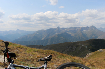
The push section is short and made slightly more difficult by gusts of wind. The view from the summit is incredible: Rasciassa, Viso Mozzo, Viso di Vallanta. And then down a hundred meters Pelvo d'Elva, Rocca la Marchisa, Chersogno, Rocca la Meja.
The descent needs some consideration, although it is not particularly technical.
From Punta Nebin you descend again on the ridge to Bassa dell'Ajet altitude 2,327 m. Continue along a dirt road a few hundred meters, near the hairpin bend to the right you begin to descend on grassland without a well-defined path along the Costa Cavallina: in the first section take as a reference the light pylons and a grange. Having bypassed the building, continue to descend through meadows keeping the light pylons on the right, gradually approaching the asphalt ascent road to Colle Cavallina elevation 1,940 m.
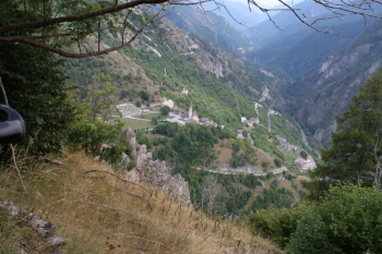
At the Colle a sign indicates Cappella San Giovanni a 10-minute walk away, originally a square plan and later rebuilt in its present oval shape to better counteract the wind. The Chapel is situated on the Colle of the same name at an elevation of 1,850 m. , opposite stands Mount Chersogno on the left appreciated source of water and the beginning of the Occitan trail on an easy path of MC difficulty to San Martino. Continue to Colle Bettone at an altitude of 1,831 m. and then downhill to cut several times the asphalt road always with clear signs. The last junction you turn right to enter the hamlet of San Martino 1,431 m. Between the 1970s and 1980s, after a period of abandonment, the hamlet experienced symptoms of recovery: under the church there are remains of an old windmill with circular turret, a stone arch in the center of the hamlet, the working wood-burning oven, wash houses, the old school, and a votive pillar dated 1788.
In the narrow alleys one must keep to the left to rejoin the path this time classifiable as BC overall and follow the beautiful ciamino to the balcony over Stroppo. You arrive on SP 335 at the hairpin bend preceding Stroppo. With the last few pedalings you return to the parking lot.
For those who want to do a route of reduced difficulty, it is better to start from San Martino, arrive at the Sampeyre Pass, exclude pushge to Mt. Nebin, do the MC descent to San Martino.
Fraternali publisher no. 11 upper Maira Valley - Trail map (1:25,000)