HOME RANKINGS CHALLENGES ROUTES NEAR ME PLANNING SEARCH LOGIN
Italy - Lombardia, BG
2023/03/19 20:54:51

Strada Regia - Trail XC panoramico

166 Downloads
8
 
Share

Key Takeaways / Scheda Tecnica

Disciplina:
Mountain Bike (MTB)
Percorso:
Strada Regia - Trail XC panoramico
Località:
Italy - Lombardia, BG
Distanza:
46,84 km
Dislivello Positivo:
+1 300 mt (Quota Min: 202m - Max: 685m)
Difficoltà Tecnica:
2/5
Valutazione Panorami:
5/5
Formato Traccia:
GPX Download disponibile
Author
ValeBG
(181)
Place
Italy - Lombardia, BG
Km
46,84 km
Elapsed time
07:04:40
Vertical meters
+1 300 mt (202 - 685)
Route difficulty
Landscapes
Last update
2023/03/20 21:14:46
Comments
1
Description

This weekend we went for a more leisurely ride, with views of the lake and a wonderful midslope trail!

Foto itinerario MTB Strada Regia - Trail XC panoramico - Italy - Lombardia, BG

Parked in Como after a short while, we immediately detour onto a nice dirt climb that completely avoids traffic and via other roads leads to Brunate. Past the village the Strada Regia begins. A well-maintained hillside path.

Foto itinerario MTB Strada Regia - Trail XC panoramico - Italy - Lombardia, BG

Foto itinerario MTB Strada Regia - Trail XC panoramico - Italy - Lombardia, BG

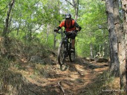
The only descent worthy of the name is right at the beginning of the trail about 150 meters of elevation gain over 2km.

Foto itinerario MTB Strada Regia - Trail XC panoramico - Italy - Lombardia, BG

Then it continues with a very nice up and down-.

Interesting on the trail is the 'viper stone'.

Foto itinerario MTB Strada Regia - Trail XC panoramico - Italy - Lombardia, BG

The hanging stone

Foto itinerario MTB Strada Regia - Trail XC panoramico - Italy - Lombardia, BG

And many scenic spots.

Foto itinerario MTB Strada Regia - Trail XC panoramico - Italy - Lombardia, BG

The last nice descent closes in Palanzo from which via the somewhat boring state road back to the starting point (I recommend light for short tunnel passage). The tour has a fairly low difficulty. It still deserves a moment's attention in some places and a minimum of experience (as well as leg). For those who feel like doing more meters uphill, another good alternative from Lemma is to go up to the Molina pass and then down to Albavilla.

Final stage the cathedral of Como

Foto itinerario MTB Strada Regia - Trail XC panoramico - Italy - Lombardia, BG

Download our free mobile app to send this route to your Garmin device or to navigate it on OSM maps. Android - iOS
Local weather
Tue 00:00
13 °C
Tue 12:00
17 °C
Wed 00:00
16 °C
Wed 12:00
17 °C
Thu 00:00
15 °C
Thu 12:00
16 °C
Fri 00:00
11 °C
Fri 12:00
13 °C
Sat 00:00
10 °C
Sat 12:00
15 °C

Graph

Nearest Routes

2022/11/12
- Italy - Lombardia, CO
educlimb
(4)
100,67 km
Km
+2 515 mt
Vertical meters
Route difficulty
Landscapes
2023/06/20
- Italy - Lombardia, CO
gianpt
(3)
82,49 km
Km
+3 000 mt
Vertical meters
Route difficulty
Landscapes
2023/06/17
- Italy - Lombardia, CO
gianpt
(3)
33,16 km
Km
+1 250 mt
Vertical meters
Route difficulty
Landscapes
2025/09/20
- Italy - Lombardia, CO
gianpt
(3)
57,06 km
Km
+1 933 mt
Vertical meters
Route difficulty
Landscapes
2023/03/12
- Italy - Lombardia, CO
33,70 km
Km
+300 mt
Vertical meters
Route difficulty
Landscapes
2023/12/09
- Italy - Lombardia, CO
marco
(195)
15,57 km
Km
+687 mt
Vertical meters
Route difficulty
Landscapes
2023/06/18
- Italy - Lombardia, CO
tado79
(16)
68,01 km
Km
+2 400 mt
Vertical meters
Route difficulty
Landscapes
2025/04/28
- Switzerland
euvanet
(6)
21,47 km
Km
+1 100 mt
Vertical meters
Route difficulty
Landscapes
2023/04/20
- Italy - Lombardia, CO
buscascin
(1)
18,87 km
Km
+900 mt
Vertical meters
Route difficulty
Landscapes
26,49 km
Km
+2 009 mt
Vertical meters
Route difficulty
Landscapes

1 Comments