HOME RANKINGS CHALLENGES ROUTES POI PLANNING SEARCH LOGIN
Italy - Trentino-Alto Adige/Südtirol, TN
2023/03/08 08:07:25

Monte Creino - Naranch - Anaconda

55 Downloads
5
 
Author
nonnocarb
(266)
Place
Italy - Trentino-Alto Adige/Südtirol, TN
Km
23,53 km
Elapsed time
05:38:34
Vertical meters
+1 300 mt (221 - 1298)
Route difficulty
Landscapes
Last update
2023/10/31 11:01:49
Comments
0
Description

Challenging route both uphill and downhill, reserved for experienced and trained bikers. From Loppio you immediately climb on the very steep path that cuts the provincial road; to warm up well it is perhaps better to start from Nago and warm up on the bike path.

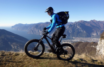
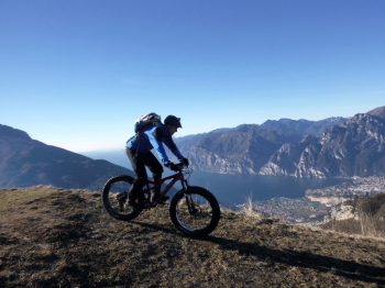
Still on secondary roads you arrive at Ronzo Chienis and the S. Barbara pass. From here continue to the top of Mount Creino, with splendid views of the Brenta and Lake #garda. You descend along the beautiful Creino trenches and then on the Naranch trail.

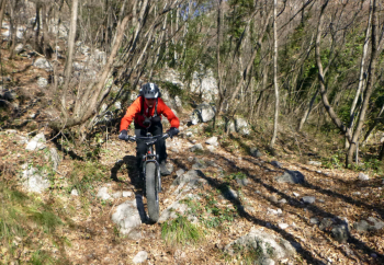
Go up for 10 minutes on the Ziresole forest road and take the Anaconda trail (no bikes, watch out for pedestrians especially in high season). The first part is challenging but smooth, while the second part is very challenging with lots of boulders also large and loose. You arrive in Nago and return to the bike path in Loppio.

#garda

Download our free mobile app to send this route to your Garmin device or to navigate it on OSM maps. Android - iOS

Graph

Nearest Routes

2023/12/21
- Italy - Trentino-Alto Adige/Südtirol, TN
32,04 km
Km
+1 700 mt
Vertical meters
Route difficulty
Landscapes
2022/10/02
- Italy - Trentino-Alto Adige/Südtirol
47,30 km
Km
+1 972 mt
Vertical meters
Route difficulty
Landscapes
2023/03/10
- Italy - Veneto, VR
civi65
(100)
60,95 km
Km
+10 mt
Vertical meters
Route difficulty
Landscapes
2024/01/03
- Italy - Trentino-Alto Adige/Südtirol, TN
36,63 km
Km
+1 848 mt
Vertical meters
Route difficulty
Landscapes
2022/10/21
- Italy - Trentino-Alto Adige/Südtirol, TN
biciclitu
(12)
32,95 km
Km
+2 118 mt
Vertical meters
Route difficulty
Landscapes
2023/05/19
- Italy - Trentino-Alto Adige/Südtirol, TN
37,21 km
Km
+1 900 mt
Vertical meters
Route difficulty
Landscapes
2023/04/18
- Italy - Trentino-Alto Adige/Südtirol, TN
pozzoligio
(87)
84,52 km
Km
+2 300 mt
Vertical meters
Route difficulty
Landscapes
2023/04/16
- Italy - Trentino-Alto Adige/Südtirol, TN
pozzoligio
(87)
23,90 km
Km
+1 303 mt
Vertical meters
Route difficulty
Landscapes
2023/04/18
- Italy - Trentino-Alto Adige/Südtirol, TN
pozzoligio
(87)
79,85 km
Km
+2 900 mt
Vertical meters
Route difficulty
Landscapes
2023/04/19
- Italy - Trentino-Alto Adige/Südtirol, TN
pozzoligio
(87)
43,86 km
Km
+1 600 mt
Vertical meters
Route difficulty
Landscapes

0 Comments