Italiano
 Deutsch
Monte Altissimo Trail 601 + Coast Trail

This sumptuous itinerary starts from the town of Torbole in a small book parking lot at the end of Via Piccola. We proceed toward the hundred on a one-way road and ascend to the Busatte Park, go around the Dos Termin until we join the carriageway that climbs from Nago to Malga Zures to the Prati di Nago and the North/East Saddle of Monte Varagna.
A very comfortable road with very steep segments and beautiful views that give us a foretaste of what the high altitude landscape holds in store. Up to the saddle at 1700 meters nothing to report, we pedal on.
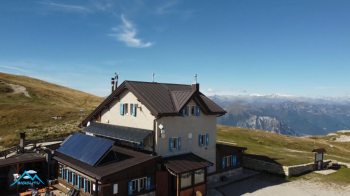
At the saddle we ignore the path that climbs to the right (it will be the descent) and also the one that descends sharply toward Malga Campei, we decline gently, (about 100m) in the direction of Bocca Poltrane that we already glimpse in front of us at 1813 meters. After the short descent there is little pedaling, we push up to the Bocca. Once we reach Bocca Poltrane we follow the Alta Via del Monte Baldo trail N°622 to the right, which with pedaled stretches, pushed stretches and with bikes on our backs will lead us directly to the Damiano Chiesa Refuge.
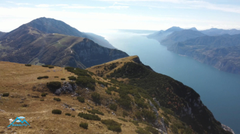
From the hut just a few more meters and the effort (uphill) is over, we are on the summit of the meadowy Monte Altissimo also highlighted by the consistent trigonometric marker. The panorama that this summit reveals to us will not leave any of us indifferent, too too beautiful! We bardiamo and now await 2000 meters of descent fun if you have confidence with the mtb but never, never trivial, on the contrary!
The first scenic segment will lead us back to the saddle of Monte Varagna then we follow the 601 to the Malga Casina, we have thus descended 1000 meters cutting the road taken uphill 10 times. Now after the source acqua d'oro (declared non-drinkable...) we take the mythical Coast Trail that with technical and scenic passages will lead us with effort and a lot of fun to the Busatte.
One more stretch of technical trail and a staircase where our attention will be mainly directed towards possible pedestrians we will shortly gain the shore of Lake #garda and the center of Torbole. Sensational ride, to be tackled with the right preparation and attention.