2023/03/05 22:13:23
Sul monte Rota
Author
Place
Italy - Trentino-Alto Adige/Südtirol, BZ
Km
33,21 km
Elapsed time
74:28:35
Vertical meters
+750 mt (1181 - 1819)
Route difficulty
Landscapes
Last update
2023/03/06 08:32:08
Comments
Description
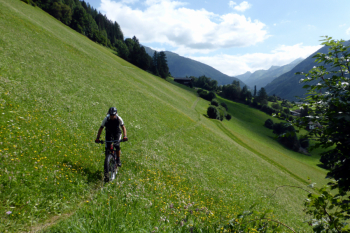
Route not technically difficult, but challenging due to very steep climbs. Very beautiful views of the Casies and Pustertal valleys.

From Dobbiaco, you climb to Mt. Rota and then, on a very steep trail, to the Roman path, which you walk entirely to the west. Go around the mountain, toward the Casies valley, and follow the long forest trail up and down to the east. When you reach Franadega, you take the forest road toward Mount Rota. From here you can admire the splendid panorama toward the Landro valley and the Braies Dolomites. A path with some challenging sections takes us back to the starting point.

Local weather
Today

20 °C
Tonight

7 °C
Tomorrow

19 °C
Tomorrow night

6 °C
Sunday

18 °C
Sunday night

7 °C
Graph
Nearest Routes
48,18 km
Km
+1 500 mt
Vertical meters
Route difficulty
Landscapes
48,18 km
Km
+1 684 mt
Vertical meters
Route difficulty
Landscapes
34,64 km
Km
+1 320 mt
Vertical meters
Route difficulty
Landscapes
2023/03/05
- Italy - Trentino-Alto Adige/Südtirol, BZ 46,65 km
Km
+450 mt
Vertical meters
Route difficulty
Landscapes
22,60 km
Km
+1 100 mt
Vertical meters
Route difficulty
Landscapes
2023/02/26
- Italy - Trentino-Alto Adige/Südtirol, BZ 34,09 km
Km
+1 420 mt
Vertical meters
Route difficulty
Landscapes
28,95 km
Km
+1 110 mt
Vertical meters
Route difficulty
Landscapes
28,41 km
Km
+510 mt
Vertical meters
Route difficulty
Landscapes
2023/03/05
- Italy - Trentino-Alto Adige/Südtirol, BZ 118,42 km
Km
+1 920 mt
Vertical meters
Route difficulty
Landscapes
51,40 km
Km
+1 210 mt
Vertical meters
Route difficulty
Landscapes


 Italiano
 Deutsch