HOME RANKINGS CHALLENGES ROUTES POI PLANNING SEARCH LOGIN
Italy - Trentino-Alto Adige/Südtirol, BZ
2023/02/26 17:09:16

Al rifugio Bonner sulla neve

5 Downloads
0
 
Author
nonnocarb
(266)
Place
Italy - Trentino-Alto Adige/Südtirol, BZ
Km
22,60 km
Elapsed time
03:05:44
Vertical meters
+1 100 mt (1136 - 2309)
Route difficulty
Landscapes
Last update
2023/12/04 13:47:28
Comments
0
Description

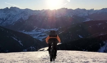
This is a route that can also be ridden in summer, but it is at its best in winter, when the #snow covers meadows and roads and increases the fun of this ride. The important thing is to start when the snow is sufficiently groomed and aged, to be able to ride in it at its best, and on a high-pressure day, to be able to admire at its best the splendid view from the hut.

When you reach the village of Candelle, the snow-covered road begins and you climb up forestry with steep sections, always pedaling until the end of the forest. From here you have to climb pushing your bike up to the hut for the last 300 meters of elevation gain, or better with your bike on your back and snowshoes on your feet (previously tied to your backpack). If you go up by e-bike, you can ride almost all the way if the snow is hard enough.

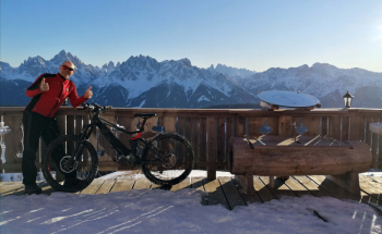
At the hut, we can rest and enjoy typical and well-cooked specialties. If snow permits, we can continue with snowshoes up to the Fana Horn (2663 m) with 360° spatial views of the Austrian Alps and Dolomites.

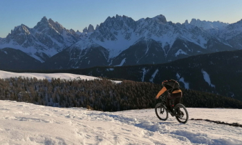
The descent is great fun on packed snow and open terrain, then into the woods and again on grassland to Candelle. A stretch of road and then through Valle S. Silvestro, then over a nice snowy trail to Toblach. Still on trail by the brook almost to the campground.

Download our free mobile app to send this route to your Garmin device or to navigate it on OSM maps. Android - iOS

Graph

Nearest Routes

2023/03/01
- Italy - Trentino-Alto Adige/Südtirol, BZ
nonnocarb
(266)
48,18 km
Km
+1 500 mt
Vertical meters
Route difficulty
Landscapes
2022/10/28
- Italy - Trentino-Alto Adige/Südtirol, BZ
nonnocarb
(266)
48,18 km
Km
+1 684 mt
Vertical meters
Route difficulty
Landscapes
2023/03/05
- Italy - Trentino-Alto Adige/Südtirol, BZ
nonnocarb
(266)
33,21 km
Km
+750 mt
Vertical meters
Route difficulty
Landscapes
2023/02/26
- Italy - Trentino-Alto Adige/Südtirol, BZ
nonnocarb
(266)
28,41 km
Km
+510 mt
Vertical meters
Route difficulty
Landscapes
2023/03/05
- Italy - Trentino-Alto Adige/Südtirol, BZ
nonnocarb
(266)
34,64 km
Km
+1 320 mt
Vertical meters
Route difficulty
Landscapes
2023/03/05
- Italy - Trentino-Alto Adige/Südtirol, BZ
nonnocarb
(266)
46,65 km
Km
+450 mt
Vertical meters
Route difficulty
Landscapes
2023/02/26
- Italy - Trentino-Alto Adige/Südtirol, BZ
nonnocarb
(266)
34,09 km
Km
+1 420 mt
Vertical meters
Route difficulty
Landscapes
2023/03/05
- Italy - Trentino-Alto Adige/Südtirol, BZ
nonnocarb
(266)
118,42 km
Km
+1 920 mt
Vertical meters
Route difficulty
Landscapes
2023/03/05
- Italy - Trentino-Alto Adige/Südtirol, BZ
nonnocarb
(266)
51,40 km
Km
+1 210 mt
Vertical meters
Route difficulty
Landscapes
2023/03/05
- Italy - Trentino-Alto Adige/Südtirol, BZ
nonnocarb
(266)
28,95 km
Km
+1 110 mt
Vertical meters
Route difficulty
Landscapes

0 Comments