2023/03/05 08:16:36
Giggelberg, Nassereto e sentiero 8b
Author
Place
Italy - Trentino-Alto Adige/Südtirol, BZ
Km
36,69 km
Elapsed time
36:29:46
Vertical meters
+1 310 mt (301 - 1674)
Route difficulty
Landscapes
Last update
2025/03/11 08:01:07
Comments
Description
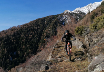
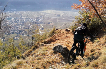
Very challenging route, both for the long climb and the technical downhill trail, but very scenic and fun.

From Merano you go up to Parcines, then very steep and hard climb to the village exit. After the turn you climb more steadily and arrive at the Giggelberg farm (refreshment). From here a nice trail, with a portage section, leads to the Nassereto hut. Best not to do this trail in high season because it is very, too busy. From the hut (refreshment), descend on a challenging trail back to Parcines, and then on a scenic road to Merano.

Local weather

°C

°C

°C

°C

°C

°C
Graph
Nearest Routes
44,14 km
Km
+2 100 mt
Vertical meters
Route difficulty
Landscapes
48,57 km
Km
+1 550 mt
Vertical meters
Route difficulty
Landscapes
61,08 km
Km
+2 334 mt
Vertical meters
Route difficulty
Landscapes
61,08 km
Km
+2 334 mt
Vertical meters
Route difficulty
Landscapes
51,00 km
Km
+1 610 mt
Vertical meters
Route difficulty
Landscapes
105,14 km
Km
+3 200 mt
Vertical meters
Route difficulty
Landscapes
31,25 km
Km
+1 100 mt
Vertical meters
Route difficulty
Landscapes
2023/03/04
- Italy - Trentino-Alto Adige/Südtirol, BZ 47,13 km
Km
+1 100 mt
Vertical meters
Route difficulty
Landscapes
64,04 km
Km
+2 200 mt
Vertical meters
Route difficulty
Landscapes
76,06 km
Km
+2 300 mt
Vertical meters
Route difficulty
Landscapes


 Italiano
 Deutsch