
 Italiano
 Deutsch
2023/03/04 08:09:55
Malga di Laces e barbarossa trail
Author

Place
Italy - Trentino-Alto Adige/Südtirol, BZ
Km
26,12 km
Elapsed time
03:16:47
Vertical meters
+1 250 mt (628 - 1832)
Route difficulty
Landscapes
Last update
2023/03/04 08:13:41
Comments
Hotels
Description
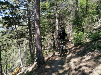
From Laces you go up to the Laces alpine hut (refreshment) via a fairly long forest road.
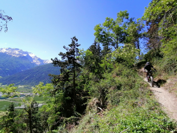
From the hut you climb a little more and then cross the Barbarossa trail, dedicated only to bikes, which is very fun and returns to Laces. Fun route with beautiful views of the Venosta valley.
Local weather
Do 00:00

19 °C
Do 12:00

27 °C
Fr 00:00
22 °C
Fr 12:00
24 °C
Sa 00:00
20 °C
Sa 12:00

26 °C
Graph
Nearest Routes
51,34 km
Km
+980 mt
Vertical meters
Route difficulty
Landscapes
72,93 km
Km
+2 970 mt
Vertical meters
Route difficulty
Landscapes
32,13 km
Km
+2 033 mt
Vertical meters
Route difficulty
Landscapes
37,04 km
Km
+1 770 mt
Vertical meters
Route difficulty
Landscapes
2024/01/10
- Italy - Trentino-Alto Adige/Südtirol, BZ 27,47 km
Km
+1 500 mt
Vertical meters
Route difficulty
Landscapes
2023/07/26
- Italy - Trentino-Alto Adige/Südtirol, BZ 28,35 km
Km
+1 500 mt
Vertical meters
Route difficulty
Landscapes
2023/06/01
- Italy - Trentino-Alto Adige/Südtirol, BZ 31,15 km
Km
+1 173 mt
Vertical meters
Route difficulty
Landscapes
30,40 km
Km
+1 865 mt
Vertical meters
Route difficulty
Landscapes
2025/08/12
- Italy - Trentino-Alto Adige/Südtirol, BZ 43,72 km
Km
+2 550 mt
Vertical meters
Route difficulty
Landscapes
28,35 km
Km
+1 500 mt
Vertical meters
Route difficulty
Landscapes