HOME RANKINGS CHALLENGES ROUTES NEAR ME PLANNING SEARCH LOGIN
Italy - Trentino-Alto Adige/Südtirol, BZ
2022/08/22 21:13:20

Croda delle Cornacchie 3251m.

8 Downloads
1
 
Share
Author
nonnocarb
(292)
Place
Italy - Trentino-Alto Adige/Südtirol, BZ
Km
30,40 km
Elapsed time
05:59:55
Vertical meters
+1 865 mt (1708 - 3250)
Route difficulty
Landscapes
Last update
2023/02/05 08:51:31
Comments
0
Description

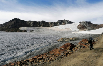
3251 meters is perhaps the highest point in the Alps that can be reached without ever getting off the bike.

You get to Grawand, Croda delle Cornacchie, above the top station of the Val Senales cable car. A fair 3000 meters of elevation gain starting from Merano, but we started from Vernago Lake in Val Senales and did 1500.

Some info: the climb is very hard, with several long stretches at 33%, so you can only fully pedal by ebike (and even with that not everyone will succeed), with normal mtb you can climb but you have to calculate half an hour to an hour of pushing bike. You actually pedal up to elevation 3212 (cable car arrival), the last 40 meters are done on foot. Descent on the same road or on the technical trail 3.

On the final section of the tour there is a trail with a push bike section and climbs, but if you want to just return to the paved road and in a few minutes you are there!

The setting is spectacular, with magnificent views of the surrounding high peaks and with the red rocks contrasting with the green mountain lakes and white ice (what little is left now!).

Download our free mobile app to send this route to your Garmin device or to navigate it on OSM maps. Android - iOS
Local weather
°C
°C
°C
°C
°C
°C
°C
°C
°C
°C

Graph

Nearest Routes

2023/03/04
- Italy - Trentino-Alto Adige/Südtirol, BZ
nonnocarb
(292)
28,35 km
Km
+1 500 mt
Vertical meters
Route difficulty
Landscapes
2024/10/24
- Italy - Trentino-Alto Adige/Südtirol, BZ
Staff
(84)
19,65 km
Km
+1 700 mt
Vertical meters
Route difficulty
Landscapes
2024/09/04
- Italy - Trentino-Alto Adige/Südtirol, BZ
nonnocarb
(292)
31,33 km
Km
+1 500 mt
Vertical meters
Route difficulty
Landscapes
2024/08/12
- Italy - Trentino-Alto Adige/Südtirol, BZ
steve-U
(23)
35,58 km
Km
+1 292 mt
Vertical meters
Route difficulty
Landscapes
2024/10/29
- Italy - Trentino-Alto Adige/Südtirol, BZ
nonnocarb
(292)
35,52 km
Km
+1 400 mt
Vertical meters
Route difficulty
Landscapes
2024/01/05
- Italy - Trentino-Alto Adige/Südtirol, BZ
nonnocarb
(292)
18,66 km
Km
+1 050 mt
Vertical meters
Route difficulty
Landscapes
2023/03/04
- Italy - Trentino-Alto Adige/Südtirol, BZ
nonnocarb
(292)
26,12 km
Km
+1 250 mt
Vertical meters
Route difficulty
Landscapes
2023/03/07
- Italy - Trentino-Alto Adige/Südtirol, BZ
nonnocarb
(292)
51,34 km
Km
+980 mt
Vertical meters
Route difficulty
Landscapes
2022/10/30
- Italy - Trentino-Alto Adige/Südtirol, BZ
nonnocarb
(292)
72,93 km
Km
+2 970 mt
Vertical meters
Route difficulty
Landscapes
2022/10/26
- Italy - Trentino-Alto Adige/Südtirol, BZ
nonnocarb
(292)
32,13 km
Km
+2 033 mt
Vertical meters
Route difficulty
Landscapes

0 Comments