7 passi del Tigullio
Departing from any of the Tigullio municipalities, you bike nimbly between Chiavari and Sestri Levante.
One pedals along the entire Fontanabuona on busy asphalt on weekdays, better on holidays. Should one prefer it, it is possible to bypass the asphalt with the slate bike path.
In any case, at Pian dei Ratti take the asphalt right to Isolona and Orero, continue climbing nimbly to Croce d'Orero where the gradients change and become more arduous and the road becomes unpaved after reaching Mount Zuccarello. After a false flat you enter a hairpin bend, follow the dirt road to the right uphill until the end of the road, 20 m before the final clearing you take a path uphill where you have 100 m of elevation gain on your bike. At the first fork go uphill to the left, watch out for the second fork where you have to leave the main path for a path to the right that keeps halfway up the hill. From here it is a succession of technical and less technical passages that takes us to Romaggi Pass. Beware of this part of the trail in case of wet bottom, the rock tends to be slippery and the trail is exposed in some places.

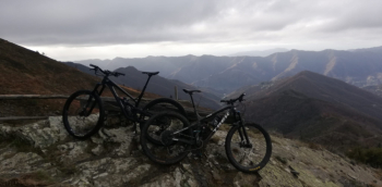
When you reach Romaggi pass, cross the road and take the path to the left from the pass sign, which follows the entire crest of Mount Pissacqua, the first part has technical ramps in the second part you have to run the bike. Always follow the ridge trail. When you reach a clearing with a few small tables, take the left for the Chestnut Trail and the subsequent Mountain Trail (at the end of the Chestnut Trail you have to climb over a chain on the right to connect with the Mountain Trail). If you were steep lovers at the clearing you can continue straight ahead and after a short climb to Mount Pissacqua face the steep Ginepraio, which connects back to the via dei monti. When you reach the end of the path you descend by asphalt to San Martino del Vento and then to San Colombano, at the end of the descent you take the asphalt road on the left to Carasco from where you head to the starting point, again you can take advantage of the slate bike path.


 Italiano
 Deutsch