Italiano
 Deutsch
Deiva Marina - San Nicolao - Monte Rospi - Costa di Framura

One of the many feasible combinations in Deiva Marina that combines the pleasure of an allmountain ride with the fun of almost completely natural enduro descents.
Departure always from the large parking lot of Deiva to immediately shoot ourselves a nice all asphalt climb that takes us on the road to the Bracco Pass. I would have liked to immediately start with a shorter climb to face the Fumarupe but the idea of completely re-experiencing the elevation gain doesn't appeal to me and in spite of myself today I give up this nice descent and opt for a double ascent to Mount San Nicolao with its bristly climb.We face in sequence first the Baracchino trail with its beautiful panoramic views and technical passages and second the long Rai also very beautiful and varied.
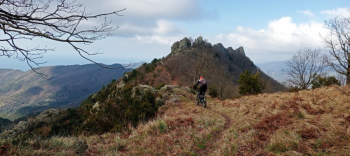
Back on the road we walk along little asphalt to abandon it in favor of the Cai 645 trail that passes just below the summit of Monte Rospi in a beautiful Mediterranean environment. A short but very pleasant trail with panoramic views and a bumpy bottom in places. Once on the road we continue the descent to turn a little further on the left onto a dirt road that leads to the Cai 650 trail that passes through Castagnola and takes us to Costa di Framura with this last very particular and suggestive stretch.
We continue on the Cai 651 trail passing Foce a Prato and continue to Case Serro where the last descent of the day awaits us, the CIAPAROCK, a differently flowing trail for pure wielders with really bad passages, but which releases pure adrenaline and satisfaction once finished.
I give it 5 stars of difficulty for the commitment it takes to Ciaparok at the end of the ride.