
 Italiano
 Deutsch
DEIVA MTB - Tour dei Bracconieri
With this itinerary we have tried to condense in the same ride an exploratory part, north of the Aurelia, with proven (by others) descents facing the sea, all in 52km for a little less than 1900 meters of elevation gain (but it will seem a lot more because of the stiff legs!).
From the village of Deiva we head on comfortable asphalt in the direction of the Via Aurelia, which we reach at the height of the Hotel Baracchino (a destination for pilgrims on one of several Via Francigena routes), which we leave almost immediately to take the steep (and we'll have to do it twice !) service road that leads to the radio-TV antennas.
Baracchino descent: we thus take the first descent that skirts the very special Pietra della Vasca, giving us priceless views of the Tigullio Gulf, Sestri, Moneglia and Deiva. Having reached the Bracco Pass (we will explain more in the following) we return along the Aurelia road to take the steep access to the antennas. This time, having reached the top, we follow the forest road that starts on the right in the direction of the day's destination: the very famous Cima Stronzi.
A brief historical excursus: the toponymy of this area of Liguria owes much to the settlements of brigands and poachers. At the Bracco Pass it was customary to find oneself in one's underwear after unpleasant encounters, in fact, where else but at "Moneglia" could the precious gold jewelry stolen from unsuspecting travelers be hidden? So why Cima Stronzi? Quite simply, this represented the best lookout point in the area, from which the lookout brigands could warn their stationed companions of the arrival of the "Stronzi" (the rich). It was not uncommon, on windless days, to hear choruses rising from the summit "the assholes, the assholes!" Reaching our summit we realize how true the voices on the summit were, in fact the panorama allows us to see from Santa Margherita to La Spezia on the sea, from the Apuan Alps to the Apennines inland.
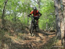
Second descent, we take the Valico della Mola (where the brigands' knives were sharpened) passing below Cima Groppi, with almost lunar terrain full of rounded stones to untangle. Then up to the Bracco Pass, the Incisa ridge awaits us (we wanted to explore but too many thorns), which, passing through Monte Crocetta, the crossroads between Moneglia and Deiva, leads us into the village on an exposed path, initially flowing but then gradually becoming more and more technical. Having sighted the beach, all we have to do is go back up on asphalt and take, in the locality of Ca de Lazzino, the ancient mule track that leads us to Framura, another panoramic balcony over the sea. A last push uphill in sections takes us sheer above Deiva to take the icing on the cake of the day, the Ciaparoc.
A trail that shares terrain with S.Anna in Sestri, but enclosed in the woods to leave us no way out! A continuous crescendo of difficulty (you will regret the S.Anna) that ends with ramps that either do or die to bring us straight back to the beach at sunset. Time for a well-deserved sandwich at the Circolo Acli with Menabrea Rossa (promotional message) and we say goodbye to Cima Stronzi lit by the last rays of the sun.


