
 Italiano
 Deutsch
Monte Bignone

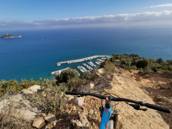
Very interesting itinerary both in terms of quality of trails and level views of the entire Alassio coastline. There is a multitude of trails in the area that allow you to modulate the tour as you see fit.
Departing from Albenga, you climb up to the Via Augusta but instead of taking it you continue on slopes that are not exactly warming. The road becomes a dirt road and when we get to where it flattens we keep to the left, ignoring the numerous forks until we take the path that descends from the Bignone. The first section is quite technical and stays on the ridge, then we abandon it to take the path (Onda) on the left that makes a beautiful eat-and-drink traverse under the Bignone with super panorama. When we reach a crossroads we descend for the maximum slope (going straight on would make a shortcut), the trail (S.Croce Cliff) here is wonderful but quite technical, overhanging the sea and with passages on ciappe and tight curves also on dirt.
When we reach the asphalt we climb up until we take the wide dirt road to Mount Pisciavino and at the first hairpin bend we abandon it to take the beautiful trail that climbs in traverse cutting under the summit and arriving at the col below. From the col we continue on fun and hyper scenic trail on the ridge and traverse until we reach the col below Mt. Bignone.
We pass on the north side, now in the woods, following the beautiful Fonte Carbonara trail, at a flat junction we go right until we reach the ridge traveled uphill, once on the dirt road we go straight to take path parallel to the dirt road to go to take the upper part of the Tornante trail that descends to the left, then follow the trail because there are several forks, you will find yourself on the second part of the very fun Tonante trail with banks and jumps never too challenging until you reach the road.


