HOME RANKINGS CHALLENGES ROUTES POI PLANNING SEARCH LOGIN
Italy - Liguria, GE
2023/01/22 15:39:13

Cresta monte Cornua Redentore Sant'Apollinare

13 Downloads
0
 
Author
ebsat
(96)
Place
Italy - Liguria, GE
Km
32,44 km
Elapsed time
06:08:14
Vertical meters
+1 329 mt (19 - 780)
Route difficulty
Landscapes
Last update
2023/01/22 16:09:41
Comments
0
Description

Departing from Sori we head on asphalt in the direction of Canepa to reach the provincial road of Montefasce at Case Cornua. Refreshment break at the Trattoria of the same name and then restart in the opposite direction to Genoa.

A little further on we leave the road to join the path that leads to the summit of Mount Cornua from which we undertake the long traverse of the ridge to Sant'Umberto where a last, steeper section leads us to Sant'Apollinare. The ridge cannot be considered a true descent but alternates with several raises to overcome the small elevations that follow.

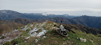
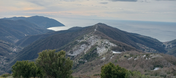
The environment, however, is very beautiful with respectable panoramic views of the sea and in the distance the copiously snow-covered Alps. There is no shortage of technical sections to try your hand at today made more complicated by a not excessive blanket of snow that made the environment truly special.From Sant'Apollinare to regain the asphalt that will take us back to the road to Montefasce and not lose altitude we take a small road typical of these Ligurian areas that crosses the village of Rupanego and leads us to Capreno where we resume the asphalt climb.

Once again reaching Case Cornua we continue on the provincial road this time in the direction of Genoa. We pass Case Becco and just below Mount Possuolo we take the path to face the descent that leads to Cortino and from the latter a stretch of mule track takes us directly to Via Giordani that runs along the Sori stream.

Download our free mobile app to send this route to your Garmin device or to navigate it on OSM maps. Android - iOS

Graph

Nearest Routes

2023/06/21
- Italy - Liguria, GE
ebsat
(96)
43,70 km
Km
+1 900 mt
Vertical meters
Route difficulty
Landscapes
2023/04/24
- Italy - Liguria, GE
ebsat
(96)
26,05 km
Km
+1 220 mt
Vertical meters
Route difficulty
Landscapes
2022/12/11
- Italy - Liguria, GE
BAROLO71
(33)
24,95 km
Km
+1 265 mt
Vertical meters
Route difficulty
Landscapes
2023/03/10
- Italy - Liguria, GE
Antosangui
(106)
14,00 km
Km
+519 mt
Vertical meters
Route difficulty
Landscapes
2023/03/02
- Italy - Liguria, GE
Antosangui
(106)
50,65 km
Km
+1 706 mt
Vertical meters
Route difficulty
Landscapes
2023/03/07
- Italy - Liguria, GE
Antosangui
(106)
17,67 km
Km
+551 mt
Vertical meters
Route difficulty
Landscapes
2023/03/26
- Italy - Liguria, GE
BAROLO71
(33)
27,63 km
Km
+1 300 mt
Vertical meters
Route difficulty
Landscapes
2023/03/23
- Italy - Liguria, GE
BAROLO71
(33)
23,29 km
Km
+1 011 mt
Vertical meters
Route difficulty
Landscapes
2023/03/04
- Italy - Liguria, GE
Antosangui
(106)
29,39 km
Km
+1 379 mt
Vertical meters
Route difficulty
Landscapes
2024/04/22
- Italy - Liguria, GE
Antosangui
(106)
29,58 km
Km
+1 387 mt
Vertical meters
Route difficulty
Landscapes

0 Comments