
 Italiano
 Deutsch
The Ridge: M. Bado - M. Castelletti - M. S.Croce

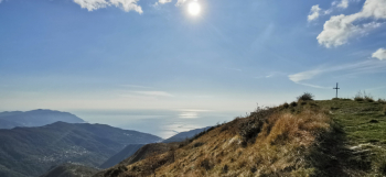
Itinerary that traverses a series of hyper panoramic ridges connecting M. Bado - M . Castelletti and M. S.Croce through a series of very beautiful and quite technical trails.
The area is very scenic and thanks to constant maintenance there are a lot of (pedestrian!) trails that are also passable by mtb with the appropriate technical skills on always fixed rock. Climb from the Sori waterfront upstream following the valley floor road that leads to Case Cornua and Case Becco.
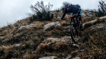
There are two possibilities of ascent , I recommend the one that goes through Canepa by which fewer cars pass. At Case Becco you leave the asphalt road and take a path that is flat but with several very fun technical passages that cut across the slopes of M. Bado. At Colle del Bado the bike passes on its back for the short climb to the summit of Bado, then along the ridge towards the sea to M. Becco.
In view of the road below we drop down along the rather steep path until we cross the road and go on the path from the other side near Case Becco. After a short climb, a beautiful traverse more or less always visible leads us to the saddle of M. Possuolo. From here we could follow the ridge integrally until the weather station and then down the ridge (very nice and technical), here instead we descend sea side on nice path until we go to take the traverse (eye you can see very little) that with very nice path, narrow and sometimes not very visible but 99% cyclable takes us to Cian da Cola (where we arrive with previous variant from the weather station).
From the pass bike again for 5 minutes to reach the spectacular summit of M. Castelletti, short stop to prepare for the technician's waltz. Those who prefer easier trail can bypass M. Castelletti with the west side trail. The ridge trail, on the other hand, traverses a series of fixed rocks with technical passages that require attention until we return to the open ridge.
We follow the trail through the scrub until we climb to the beautiful little church of S. Croce (very short walking sections). From the little church one could descend with easy east side trail, instead we aim straight to the sea by descending the staircase and then the beautiful and technical trail, narrow but always clean that ends on paved road that descends to Pieve Ligure Alta. From Pieve heart-breaking climb up to the hairpin bend from which we take the more or less level path to Terisca, after 400 meters we turn right downhill until we reach Sori. All that remains is to pass by Edo Bar to refresh yourself with farinata and typical Ligurian cakes!


