HOME RANKINGS CHALLENGES ROUTES NEAR ME PLANNING SEARCH LOGIN
Italy - Friuli-Venezia Giulia, UD
2026/10/31 18:43:05

Cima Pala mtb trail

2 Downloads
1
 
Share

Key Takeaways / Scheda Tecnica

Disciplina:
Mountain Bike (MTB)
Percorso:
Cima Pala mtb trail
Place:
Italy - Friuli-Venezia Giulia, UD
Km:
27,33 km
Vertical meters:
+1 200 mt (Quota Min: 156m - Max: 1185m)
Route difficulty:
3/5
Landscapes:
4/5
Formato Traccia:
GPX Download disponibile
Author
Place
Italy - Friuli-Venezia Giulia, UD
Km
27,33 km
Elapsed time
04:25:54
Vertical meters
+1 200 mt (156 - 1185)
Route difficulty
Landscapes
Last update
2026/10/31 18:46:51
Comments
0
Description

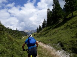
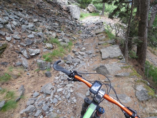
A very beautiful climb away from traffic that ascends to Cima Pala Sud (Malga Polpazzo), passing through Celante D'Asio, Clauzetto, and Pradis. From the agritourism lodge (refreshment stop), after descending past the first scenic ridge toward Ropa di Pradis, the trail changes character abruptly, becoming a very steep S3 singletrack on unstable ground with exposed rocky sections, where good balance and controlled speed are essential to avoid getting stuck. Once past the “rough” section of scree, the trail levels off near the village of Corona. The subsequent Black Mamba trail winds through tightly guided underbrush, characterized by fast stretches alternating with rough sections, counter-slopes, roots, and rocks (difficulty S1/S2). Continuing toward San Vito D’Asio, you’ll follow the medieval path while admiring the little church of San Martino. Before entering the village, turn right downhill along a path flanked by dry-stone walls. After crossing San Vito D’Asio along narrow, stepped alleys (proceed at a walking pace), you’ll reach the start of Mach3—a wonderful flow trail featuring fast, fun terrain that winds through the woods with natural obstacles and guided sections.

Start/Finish: Pradalon

Download our free mobile app to send this route to your Garmin device or to navigate it on OSM maps. Android - iOS
Local weather
Mon 00:00
9 °C
Mon 12:00
12 °C
Tue 00:00
9 °C
Tue 12:00
13 °C
Wed 00:00
11 °C
Wed 12:00
12 °C
Thu 00:00
10 °C
Thu 12:00
13 °C
Fri 00:00
15 °C
Fri 12:00
15 °C

Graph

Nearest Routes

2024/04/22
- Italy - Friuli-Venezia Giulia, PN
matiuc
(9)
37,55 km
Km
+1 250 mt
Vertical meters
Route difficulty
Landscapes
2023/03/02
- Italy - Friuli-Venezia Giulia, PN
civi65
(106)
16,36 km
Km
+920 mt
Vertical meters
Route difficulty
Landscapes
2023/07/14
- Italy - Friuli-Venezia Giulia, UD
GiGaX73
(75)
46,25 km
Km
+440 mt
Vertical meters
Route difficulty
Landscapes
2023/03/07
- Italy - Friuli-Venezia Giulia, UD
civi65
(106)
15,87 km
Km
+1 000 mt
Vertical meters
Route difficulty
Landscapes
2023/03/07
- Italy - Friuli-Venezia Giulia, PN
civi65
(106)
20,19 km
Km
+860 mt
Vertical meters
Route difficulty
Landscapes
2023/07/17
- Italy - Friuli-Venezia Giulia, PN
GiGaX73
(75)
12,25 km
Km
+800 mt
Vertical meters
Route difficulty
Landscapes
2023/07/17
- Italy - Friuli-Venezia Giulia, UD
GiGaX73
(75)
59,67 km
Km
+580 mt
Vertical meters
Route difficulty
Landscapes
2026/10/26
- Italy - Friuli-Venezia Giulia, UD
matiuc
(9)
16,68 km
Km
+800 mt
Vertical meters
Route difficulty
Landscapes
2024/11/15
- Italy - Friuli-Venezia Giulia, UD
civi65
(106)
29,53 km
Km
+1 600 mt
Vertical meters
Route difficulty
Landscapes
2024/08/16
- Italy - Friuli-Venezia Giulia, UD
gmzolenart
(137)
18,20 km
Km
+815 mt
Vertical meters
Route difficulty
Landscapes

0 Comments