HOME RANKINGS CHALLENGES ROUTES NEAR ME PLANNING SEARCH LOGIN
Italy - Friuli-Venezia Giulia, UD
2026/10/10 19:22:15

Colombina mtb trail (monte Capin di Ponente e monte Borgo)

7 Downloads
0
 
Share

Key Takeaways / Scheda Tecnica

Disciplina:
Mountain Bike (MTB)
Percorso:
Colombina mtb trail (monte Capin di Ponente e monte Borgo)
Località:
Italy - Friuli-Venezia Giulia, UD
Distanza:
25,90 km
Dislivello Positivo:
+1 311 mt (Quota Min: 774m - Max: 1696m)
Difficoltà Tecnica:
3/5
Valutazione Panorami:
4/5
Formato Traccia:
GPX Download disponibile
Author
Place
Italy - Friuli-Venezia Giulia, UD
Km
25,90 km
Elapsed time
04:53:32
Vertical meters
+1 311 mt (774 - 1696)
Route difficulty
Landscapes
Last update
2026/10/10 19:26:10
Comments
0
Description

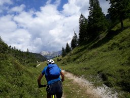
From Tarvisio Centrale, take the Alpe Adria trail. Initially, climb along the road or mule trail of Val Bartolo to the pass of the same name (about 1,173 meters). Cross the border and continue along the dirt road through the woods (toward Mount Goriane). At a junction, turn right until you reach Trail 403. Push your bike uphill (or carry it on your shoulder) along the ridge, passing near the state border markers. The slope becomes steeper in the final stretch below the summit of Monte Capin di Ponente. From the summit (1,736 meters), you can follow unofficial trails that descend along the mountain’s southeast ridge. This descent follows the somewhat steep, wooded ridge line (difficulty S1), leading to the CAI 510 forest road and Sella Canton.

From the four-way junction (with a crucifix and benches), head up the former military cart track. The forest road levels off slightly before descending steeply into the wide, wooded saddle of Sella Borgo, located right at the foot of the northern slope of Monte Borgo. To descend to Tarviso, continue on CAI 509. After a few ups and downs, you’ll need to tackle a metal ladder about 5 meters long on your mountain bike to clear a small rock ledge (fairly easy). Via wonderful rideable traverses and a bit of carrying your bike, you’ll reach the summit of Monte Borgo (no panoramic views). The trail descending to Tarvisio (509), renamed the “Colombina Trail,” offers a wonderful flow ride (difficulty S2). At the end, a long stretch of the Alpe Trail brings you back to the starting point.

Download our free mobile app to send this route to your Garmin device or to navigate it on OSM maps. Android - iOS
Local weather
Tue 00:00
8 °C
Tue 12:00
14 °C
Wed 00:00
11 °C
Wed 12:00
12 °C
Thu 00:00
11 °C
Thu 12:00
7 °C
Fri 00:00
-0 °C
Fri 12:00
10 °C
Sat 00:00
3 °C
Sat 12:00
4 °C

Graph

Nearest Routes

2023/07/11
- Italy - Friuli-Venezia Giulia, UD
GiGaX73
(75)
20,42 km
Km
+710 mt
Vertical meters
Route difficulty
Landscapes
2023/08/08
- Italy - Friuli-Venezia Giulia, UD
civi65
(106)
18,75 km
Km
+1 000 mt
Vertical meters
Route difficulty
Landscapes
2023/07/12
- Italy - Friuli-Venezia Giulia, UD
GiGaX73
(75)
18,79 km
Km
+1 100 mt
Vertical meters
Route difficulty
Landscapes
2025/08/17
- Italy - Friuli-Venezia Giulia, UD
geni
(3)
41,56 km
Km
+1 461 mt
Vertical meters
Route difficulty
Landscapes
2025/08/17
- Italy - Friuli-Venezia Giulia, UD
geni
(3)
28,07 km
Km
+1 173 mt
Vertical meters
Route difficulty
Landscapes
2023/08/04
- Italy - Friuli-Venezia Giulia, UD
ste97
(4)
59,02 km
Km
+2 827 mt
Vertical meters
Route difficulty
Landscapes
2023/11/07
- Italy - Friuli-Venezia Giulia, UD
nonnocarb
(324)
11,17 km
Km
+400 mt
Vertical meters
Route difficulty
Landscapes
2023/03/02
- Italy - Friuli-Venezia Giulia, UD
civi65
(106)
32,90 km
Km
+1 560 mt
Vertical meters
Route difficulty
Landscapes
2024/08/02
- Italy - Friuli-Venezia Giulia, UD
debonafr
(18)
8,62 km
Km
+770 mt
Vertical meters
Route difficulty
Landscapes
21,96 km
Km
+1 254 mt
Vertical meters
Route difficulty
Landscapes

0 Comments