Italiano
 Deutsch
Monte Paularo, malga Pramosio, sentiero dei Pastori e via Julia Augusta

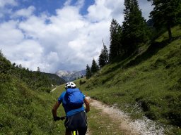
You often read in reports that this is “the most beautiful route in Carnia”; despite the absolute superlative, it turns out that there are many “most beautiful” routes, and this is certainly one of them. More than 1,700 meters of elevation gain on singletrack with difficulty levels ranging from S1 to S3, with rideable sections alternating with short stretches where you have to carry your bike. There’s a remarkable variety of scenery, from open high-mountain terrain to forest; the route is consistently scenic and varied, offering views of Mount Sernio, Mount Coglians, the Creta di Timau, and more, with frequent changes in slope. In short, a route that borders on perfection for the discerning all-mountain biker. The route does not include any sections previously featured on this site, but I believe the combination of sections is quite original.
The route starts from the Torre Picotta parking lot in Paluzza. From here, a long stretch—initially on asphalt (with very few cars)—takes us first to Ligosullo, then to Castel Valdajer, and finally along a dirt road to Casera Montelago (just under 1,400 meters higher than the starting point) after passing above Lake Dimon. Shortly after the Casera, the road ends, and you can easily push your bike all the way to the panoramic summit of Monte Paularo (2,043 meters). Descend along the same route used for the ascent (S1-S2) until reaching the junction with Trail 404, which traverses downhill along the north face of Paularo. The route is entirely bikeable except for a short uphill section (70-meter elevation gain—best carried on your shoulder) leading to the Fontanafredda Pass (S1-S2).
At this point, back on a south-facing slope (open terrain with beautiful wildflowers and views), you descend toward Casera Pramosio, first on a somewhat technical trail and then on grassy switchbacks. From Casera (which is worth a stop), descend along the service road to the quarry, which you’ll leave after a few minutes to take the shepherds’ trail (CAI 402) to the left. The trail runs mostly through the woods; it is initially very steep and technical with tight switchbacks and a few rocky outcrops (S3), but never exposed. In the second section, it becomes less steep (S2) and leads to Timau. From here, after crossing the pedestrian bridge over the But River, follow a pleasant dirt road that soon becomes a trail, running alongside the river with continuous ups and downs (S1).
For a long stretch, the river widens, surrounded by trees (a truly picturesque setting). The trail ends with a very steep incline that leads to the paved road and connects with the road climbing to Cleulis. Once you reach the village, continue uphill on a fairly steep slope until you leave the paved road and begin descending along the route of the ancient Roman road. This section is very fast-paced (S1) and, after a couple of hairpin turns, reaches the hamlet of Ramazaso with its charming little church. The gradient increases, and the cobblestone surface requires you to proceed with caution when the ground is wet. This section connects to the bike path and its footbridge over the But River, which leads to the parking lot.