HOME RANKINGS CHALLENGES ROUTES NEAR ME PLANNING SEARCH LOGIN
Italy - Friuli-Venezia Giulia, UD
2026/07/30 21:05:33

Val Dogna CAI 601

0 Downloads
0
 
Share

Key Takeaways / Scheda Tecnica

Disciplina:
Mountain Bike (MTB)
Percorso:
Val Dogna CAI 601
Località:
Italy - Friuli-Venezia Giulia, UD
Distanza:
13,56 km
Dislivello Positivo:
+700 mt (Quota Min: 848m - Max: 1569m)
Difficoltà Tecnica:
4/5
Valutazione Panorami:
4/5
Formato Traccia:
GPX Download disponibile
Author
debonafr
(18)
Place
Italy - Friuli-Venezia Giulia, UD
Km
13,56 km
Elapsed time
03:15:53
Vertical meters
+700 mt (848 - 1569)
Route difficulty
Landscapes
Last update
2026/07/30 21:08:14
Comments
0
Description

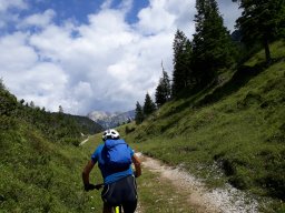
A short but very interesting route. After leaving your car in Chiut, head up the well-known forest road toward the Bieliga Pass; the trail then continues to the San Leopoldo mountain hut (water), before retracing your steps along the same route until you reach the four-way intersection below the pastures of the pass. Here, take Trail 601 (look for a red arrow on a rock; the trail is hard to spot due to forestry work). At this point, the trail winds along the extremely steep slopes of Monte Sechieiz, initially with a long traverse and then with an endless series of tight switchbacks. A truly evocative and wild setting in a sparse black pine forest, with a perfect surface completely free of rocks, and often extremely narrow switchbacks that require excellent technique (S2-S3), but the constant and severe exposure dominates the entire route, forcing a very controlled descent and, at times, even requiring you to walk your bike.

This route is definitely reserved for experienced riders; falling is absolutely forbidden. You reach the paved road a few hundred meters further down the valley from the exit of the much better-known route that descends from Cuel Tarond; while the proposed route cannot compete with that one in terms of length or scenic features, it is certainly superior from a technical standpoint. A must-try at least once.

Download our free mobile app to send this route to your Garmin device or to navigate it on OSM maps. Android - iOS
Local weather
Mar 00:00
11 °C
Mar 12:00
12 °C
Mer 00:00
11 °C
Mer 12:00
14 °C
Gio 00:00
11 °C
Gio 12:00
8 °C
Ven 00:00
5 °C
Ven 12:00
10 °C
Sab 00:00
6 °C
Sab 12:00
5 °C

Graph

Nearest Routes

2023/03/10
- Italy - Friuli-Venezia Giulia, UD
civi65
(106)
33,04 km
Km
+1 300 mt
Vertical meters
Route difficulty
Landscapes
2023/03/07
- Italy - Friuli-Venezia Giulia, UD
civi65
(106)
58,38 km
Km
+1 800 mt
Vertical meters
Route difficulty
Landscapes
2024/05/20
- Italy - Friuli-Venezia Giulia, UD
debonafr
(18)
12,41 km
Km
+800 mt
Vertical meters
Route difficulty
Landscapes
2024/06/23
- Italy - Friuli-Venezia Giulia, UD
debonafr
(18)
19,27 km
Km
+1 280 mt
Vertical meters
Route difficulty
Landscapes
2023/03/02
- Italy - Friuli-Venezia Giulia, UD
civi65
(106)
32,90 km
Km
+1 560 mt
Vertical meters
Route difficulty
Landscapes
2025/08/17
- Italy - Friuli-Venezia Giulia, UD
geni
(3)
28,07 km
Km
+1 173 mt
Vertical meters
Route difficulty
Landscapes
2025/08/17
- Italy - Friuli-Venezia Giulia, UD
geni
(3)
41,56 km
Km
+1 461 mt
Vertical meters
Route difficulty
Landscapes
2023/03/02
- Italy - Friuli-Venezia Giulia, UD
civi65
(106)
22,38 km
Km
+1 100 mt
Vertical meters
Route difficulty
Landscapes
2023/07/12
- Italy - Friuli-Venezia Giulia, UD
GiGaX73
(75)
18,79 km
Km
+1 100 mt
Vertical meters
Route difficulty
Landscapes
2023/03/02
- Italy - Friuli-Venezia Giulia, UD
civi65
(106)
26,55 km
Km
-2 800 mt
Vertical meters
Route difficulty
Landscapes

0 Comments