HOME RANKINGS CHALLENGES ROUTES NEAR ME PLANNING SEARCH LOGIN
Italy - Piemonte, CN
2026/07/18 14:21:37

Monte Bellino

50 Downloads
2
 
Share

Key Takeaways / Scheda Tecnica

Disciplina:
Mountain Bike (MTB)
Percorso:
Monte Bellino
Località:
Italy - Piemonte, CN
Distanza:
30,37 km
Dislivello Positivo:
+1 500 mt (Quota Min: 1501m - Max: 2900m)
Difficoltà Tecnica:
4/5
Valutazione Panorami:
5/5
Formato Traccia:
GPX Download disponibile
Author
Seraffo85
(21)
Place
Italy - Piemonte, CN
Km
30,37 km
Elapsed time
08:49:06
Vertical meters
+1 500 mt (1501 - 2900)
Route difficulty
Landscapes
Last update
2026/08/26 09:39:36
Comments
0
Description

The route starts at the Campo Base Mountain Hut in Chiappera (1,640 meters). To avoid the paved road, immediately upon leaving the charming village of Chiappera, take an excellent trail that runs along the hillside toward Lausetto. This initial stretch follows a scenic singletrack with short technical sections and a compact surface, interspersed with a few rocky patches, allowing you to quickly reach the opposite side of the valley without losing elevation.

Once past the village of Lausetto, take the long former military road that climbs the entire length of the Traversiera Valley toward the beautiful Carmagnola bivouac. The climb is steady and challenging: the dirt surface is generally good, but some sections have been eroded. As you ascend, the vegetation thins out, revealing a majestic and austere high-altitude landscape until you reach the 2,840-meter-high bivouac.

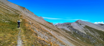
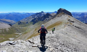
From here, there is about a 100-meter climb to reach the summit of Monte Bellino (2,942 meters). This final segment follows a ridge trail with loose, unstable scree; allow about 15–20 minutes of alternating between pedaling and carrying/pushing the bike to reach the summit cross.

The descent is a technical, continuous drop of over 1,300 meters in elevation, requiring excellent riding skills and good fatigue management. The very first section, which descends from the summit toward Colle di Bellino, features steep, loose, and slightly exposed terrain, where maximum precision in line selection is required.

From the pass, the route turns into the Maurin Valley, entering a high-mountain singletrack with a typically Alpine character. The trail features technical sections over rock, natural steps, and a series of switchbacks. In the middle and final sections, the terrain gradually becomes smoother and faster, though it still includes rough sections that require caution until the final return to the Campo Base Mountain Hut.

Note: This high-mountain route is recommended only for riders with excellent physical conditioning and experience on technical and rugged descents. Recommended bike: Full-suspension MTB.

Always check the weather conditions before setting out, as most of the loop is above 2,500 meters in elevation in a completely exposed environment.


Foto itinerario MTB Monte Bellino - Italy - Piemonte, CNFoto itinerario MTB Monte Bellino - Italy - Piemonte, CNFoto itinerario MTB Monte Bellino - Italy - Piemonte, CNFoto itinerario MTB Monte Bellino - Italy - Piemonte, CNFoto itinerario MTB Monte Bellino - Italy - Piemonte, CN

Download our free mobile app to send this route to your Garmin device or to navigate it on OSM maps. Android - iOS
Local weather
Mar 00:00
9 °C
Mar 12:00
7 °C
Mer 00:00
6 °C
Mer 12:00
12 °C
Gio 00:00
4 °C
Gio 12:00
9 °C
Ven 00:00
6 °C
Ven 12:00
7 °C
Sab 00:00
2 °C
Sab 12:00
5 °C

Graph

Nearest Routes

2025/07/08
- Italy - Piemonte, CN
marco
(195)
32,17 km
Km
+2 040 mt
Vertical meters
Route difficulty
Landscapes
2025/07/06
- Italy - Piemonte, CN
Staff
(110)
32,09 km
Km
+1 889 mt
Vertical meters
Route difficulty
Landscapes
2022/08/06
- Italy - Piemonte, CN
gmzolenart
(137)
32,26 km
Km
+1 599 mt
Vertical meters
Route difficulty
Landscapes
2025/07/18
- Italy - Piemonte, CN
Nitros
(10)
37,90 km
Km
+2 876 mt
Vertical meters
Route difficulty
Landscapes
2023/02/01
- Italy - Piemonte, CN
BAROLO71
(35)
26,62 km
Km
+1 727 mt
Vertical meters
Route difficulty
Landscapes
2022/09/24
- Italy - Piemonte, CN
gmzolenart
(137)
21,28 km
Km
+951 mt
Vertical meters
Route difficulty
Landscapes
2025/08/29
- France
30,89 km
Km
+2 050 mt
Vertical meters
Route difficulty
Landscapes
2023/12/04
- Italy - Piemonte, CN
nonnocarb
(324)
24,00 km
Km
+1 080 mt
Vertical meters
Route difficulty
Landscapes
2023/12/04
- Italy - Piemonte, CN
nonnocarb
(324)
14,54 km
Km
+850 mt
Vertical meters
Route difficulty
Landscapes
2023/12/04
- Italy - Piemonte, CN
nonnocarb
(324)
13,84 km
Km
+550 mt
Vertical meters
Route difficulty
Landscapes

0 Comments