HOME RANKINGS CHALLENGES ROUTES NEAR ME PLANNING SEARCH LOGIN
Italy - Trentino-Alto Adige/Südtirol, TN
2026/06/11 01:14:35

Cornetto del Bondone, Becca

79 Downloads
1
 
Share
Author
zambor
(2)
Place
Italy - Trentino-Alto Adige/Südtirol, TN
Km
49,29 km
Elapsed time
10:00:03
Vertical meters
+2 078 mt (176 - 2063)
Route difficulty
Landscapes
Last update
2026/06/11 07:28:21
Comments
0
Description

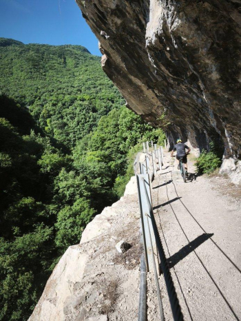
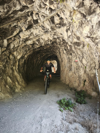
A challenging route, both technically and physically. Long stretches where you have to push your bike or carry it on your shoulder, exposed sections, and a descent that isn’t extreme but features several technical sections, some of which must be tackled on foot. The route starts in Rovereto. The first 13 km are a smooth ride on a bike path, but once you reach Aldeno, things change: you leave the pavement for a trail that starts off very tough right away. After 4 hairpin turns, it becomes more rideable, and you arrive at Covelo di Cimone, a small but very picturesque village.The route continues on asphalt to Garniga Terme, then turns onto a forest road. Initially rideable, it later features some extremely steep sections that are difficult even to push through. You emerge back onto asphalt, and for about a kilometer you can catch your breath on gentle slopes.

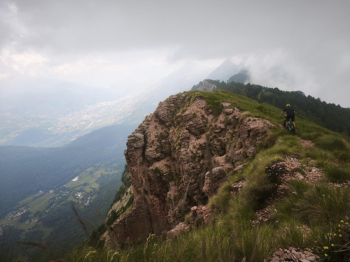
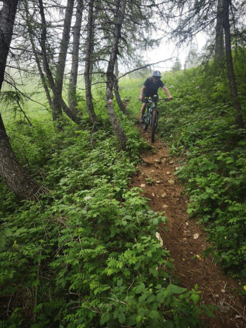
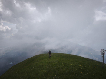
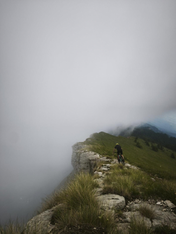
Once you reach Capanna Viote, those who wish can stop for a bite to eat, then return along a rideable forest road until you take a trail through the meadows. After a few sections that are difficult to ride, you reach the scenic bench at Costa dei Cavai. From here, the toughest stretch begins: about 3 km and 300 meters of elevation gain to be covered with your bike on your shoulder along a steep, narrow, rocky trail. Once you reach the base of Cornetto, the hard work is over. If the weather permits, you can hike to the summit; otherwise, the descent begins. You start on a barely visible trail through the meadows to reach the ridges, with exposed sections but an open view of the entire valley below. You then enter the woods and, after a few ups and downs, reach La Becca, where there’s a bench perfect for resting a few minutes. Now the trail continues with technical sections, tight switchbacks, and some very uneven stretches. The final kilometers back to the parking lot are on asphalt.

Download our free mobile app to send this route to your Garmin device or to navigate it on OSM maps. Android - iOS
Local weather
Gio 00:00
26 °C
Gio 12:00
33 °C
Ven 00:00
26 °C
Ven 12:00
33 °C
Sab 00:00
27 °C
Sab 12:00
35 °C
Dom 00:00
27 °C
Dom 12:00
34 °C
Lun 00:00
27 °C
Lun 12:00
34 °C

Graph

Nearest Routes

2025/06/07
- Italy - Trentino-Alto Adige/Südtirol, TN
Staff
(111)
30,58 km
Km
+1 250 mt
Vertical meters
Route difficulty
Landscapes
2024/06/20
- Italy - Trentino-Alto Adige/Südtirol, TN
Staff
(111)
51,67 km
Km
+2 500 mt
Vertical meters
Route difficulty
Landscapes
2025/06/07
- Italy - Trentino-Alto Adige/Südtirol, TN
Staff
(111)
59,43 km
Km
+2 200 mt
Vertical meters
Route difficulty
Landscapes
2025/06/07
- Italy - Trentino-Alto Adige/Südtirol, TN
Staff
(111)
45,29 km
Km
+1 850 mt
Vertical meters
Route difficulty
Landscapes
2025/06/07
- Italy - Trentino-Alto Adige/Südtirol, TN
Staff
(111)
39,39 km
Km
+1 950 mt
Vertical meters
Route difficulty
Landscapes
2023/03/05
- Italy - Trentino-Alto Adige/Südtirol, TN
nonnocarb
(319)
22,31 km
Km
+1 100 mt
Vertical meters
Route difficulty
Landscapes
2026/01/06
- Italy - Trentino-Alto Adige/Südtirol, TN
26,03 km
Km
+900 mt
Vertical meters
Route difficulty
Landscapes
2026/01/08
- Italy - Trentino-Alto Adige/Südtirol, TN
Maximo73
(1)
31,48 km
Km
+1 220 mt
Vertical meters
Route difficulty
Landscapes
2023/03/02
- Italy - Trentino-Alto Adige/Südtirol, TN
nonnocarb
(319)
31,15 km
Km
+1 470 mt
Vertical meters
Route difficulty
Landscapes
2025/06/07
- Italy - Trentino-Alto Adige/Südtirol, TN
Staff
(111)
51,46 km
Km
+1 900 mt
Vertical meters
Route difficulty
Landscapes

0 Comments