
 Italiano
 Deutsch
2023/03/02 18:17:13
Monte Finonchio e sentiero Teragnole
Author

Place
Italy - Trentino-Alto Adige/Südtirol, TN
Km
31,15 km
Elapsed time
05:44:28
Vertical meters
+1 470 mt (141 - 1609)
Route difficulty
Landscapes
Last update
2023/03/02 23:05:03
Comments
Hotels
Description
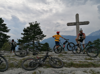
Very enjoyable and scenic itinerary with nice descents on technical trails.
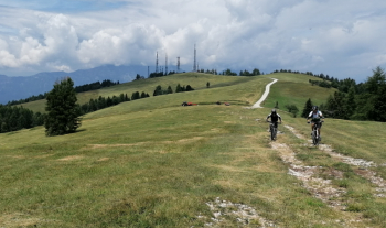
From Volano you go up the Finonchio road to the Filzi refuge (refreshment). From here take the technical trail to Potrich and then connect to the historic Teragnole trail to Noriglio. Then by secondary roads and trails back to Volano.
Local weather
Thu 00:00

20 °C
Thu 12:00

29 °C
Fri 00:00

24 °C
Fri 12:00

28 °C
Sat 00:00
21 °C
Sat 12:00
31 °C
Graph
Nearest Routes
31,48 km
Km
+1 220 mt
Vertical meters
Route difficulty
Landscapes
2026/01/06
- Italy - Trentino-Alto Adige/Südtirol, TN 26,03 km
Km
+900 mt
Vertical meters
Route difficulty
Landscapes
49,29 km
Km
+2 078 mt
Vertical meters
Route difficulty
Landscapes
30,58 km
Km
+1 250 mt
Vertical meters
Route difficulty
Landscapes
59,43 km
Km
+2 200 mt
Vertical meters
Route difficulty
Landscapes
51,46 km
Km
+1 900 mt
Vertical meters
Route difficulty
Landscapes
39,39 km
Km
+1 950 mt
Vertical meters
Route difficulty
Landscapes
45,29 km
Km
+1 850 mt
Vertical meters
Route difficulty
Landscapes
51,67 km
Km
+2 500 mt
Vertical meters
Route difficulty
Landscapes
22,31 km
Km
+1 100 mt
Vertical meters
Route difficulty
Landscapes