
 Italiano
 Deutsch
Monte Ario, Monte Visigno, Monte Croce
A small yet magnificent gem of the Val Trompia. Beautiful in every way—its setting, its views, its trails, and the fun it offers.
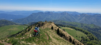
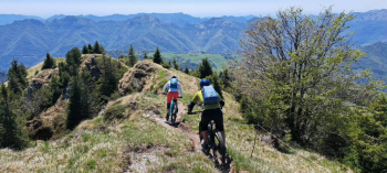
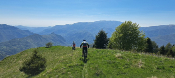
Although not particularly high (1,755 meters), Mount Ario stands isolated from the surrounding pre-Alpine hills, offering an open, sweeping panorama stretching from Lake Garda to the Orobie Alps, from the plains to—on clear days—Monte Rosa, and even as far as the pyramid of the Matterhorn. The best times to visit are spring, with its greenery and blooms, and autumn, with its vibrant colors.
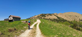
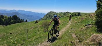
The route starts in Bovegno, near the ancient little church of San Rocco (small parking lot for two cars, or nearby), and briefly follows the bike path south before leaving it for a pleasant trail to the left. Most of the way is cycling; there are a few sections where you’ll need to push your bike, but nothing too strenuous. After a few dozen meters on a concrete path, you rejoin the trail until you emerge onto a small road, which you follow by keeping to the left until you reach the paved road that climbs from Aiale to Marmentino. Follow this road for about a kilometer and a half until you reach the village of Irma. Turning left and crossing the small square with the sundial, take the road—first paved, then concrete, and finally a dirt road—leading to the hamlet of Vezzale. From here, continue toward the hamlet of Corti along the western slopes of Mount Ario; keeping to the right, you’ll reach the Passo delle Piazze at 1,222 meters.
Turning left, on a slight descent along a dirt road, you reach the Valsabbia side of the mountain. Keep to the left until you cross the forest road that climbs to Pian del Bene, at an altitude of about 1,500 meters.
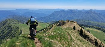
Once you reach this beautiful little plateau, pass the lower mountain hut and head toward the upper one. Just before reaching it (be careful), near a fence in the meadow, turn right (there is no actual trail, but there are rare blue-and-white trail markers on the rocks). Follow the fence until you approach a bush, climb over the barbed wire on the uphill side, and rejoin the trail (markers) which soon becomes clearly visible. This long and pleasant traverse, mostly rideable, along the eastern slopes of Mount Ario, leads to Goletto Campo di Nasso, at 1,630 meters, above the mountain hut of the same name.
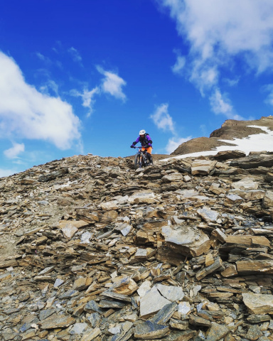
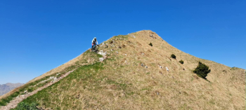
Now all that remains is to follow the steep northern ridge, first pushing the bike and then carrying it on your shoulder for about half an hour until you reach the summit cross at 1,755 meters.
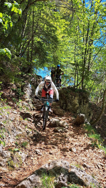
After enjoying the view, with the right gear, you descend along the spectacular, airy southern ridge, which is truly a blast (S3, max S4, some exposure).
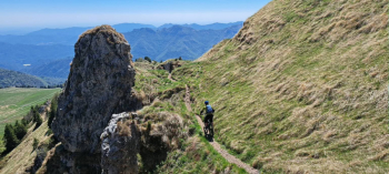
After crossing the Pian delle Bene-Malga Croce dirt road, cross it and continue straight across the meadow along the rocky, technical, and fun trail that leads back to the Passo delle Piazze (S3+, another blast).
At the pass, after removing your crampons and turning right, follow the forest road from the ascent, continuing to Passo Croce, 1,440 meters.
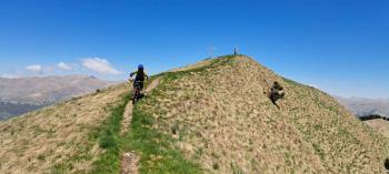
From the pass, turn left, carefully following the GPS track (there is no trail at first, but a path eventually appears), hiking for 10–15 minutes along the eastern ridge of the little-known Mount Visigno. Once you reach the small, rustic summit cross at 1,546 meters, descend along the opposite ridge for the first part, then keep slightly to the right to descend across open meadow to Malga Garotta, 1,370 meters. Here begins the Garotta trail, which is also beautiful and fun (S2 with two or three sections of S3–S4).
At an elevation of 1,100 meters, at a signposted junction on the right, it’s worth carrying your pack briefly uphill to Monte Croce, a viewpoint overlooking the village of Bovegno. The descent on the same trail is fun (S3). Resuming the trail from the junction, continue the descent. At an elevation of 965 meters, pay attention to a fork; by continuing to the right instead of the left, you avoid the final section of the marked trail, which is steep, narrow, and quite eroded. || The trail continues pleasantly and ends on a concrete path that quickly leads to the ancient village of Ludizzo.
Below the houses, the final trail begins, leading back to the Mella River. From here, do not cross the river but turn left; in ten minutes, you’ll be back at the car.


