Italiano
 Deutsch
Zucco Sileggio: 17a, la vertical che non molla un attimo

There are times when the GPS logs a route, but the web is silent. This is one of those trips. An adventure born from the desire to discover the unknown: as I was scanning the map of the area in search of new routes, my eye fell on that T2 trail marker. On paper, it looked like a harmless, easy hiking trail, but curiosity got the better of me. Pure exploration, just a few tips from hikers.
The Ascent: Conquering the Altitude
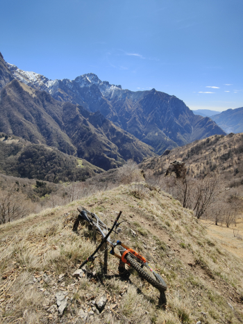
The warm-up is idyllic: the lakeside welcomes us with its dazzling beauty, but it’s just a mirage. The climb starts to bite right away with a constant, endless, grueling gradient. But it’s after Esino Lario that the challenge becomes psychological: we leave the asphalt behind for brutal off-road terrain. Here, the ground is unforgiving, and the gradients force a hand-to-hand struggle with the bike until we reach Bocchetta di Calivazzo.
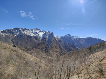
The Mezzacosta: In the Presence of the Grigna
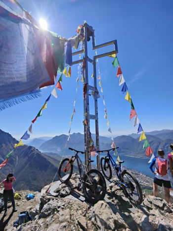
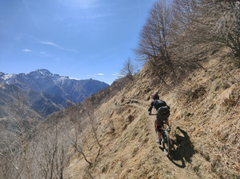
From Bocchetta, the scenery changes. The route continues along a narrow ridge path that cuts across the inner slope. Here, the lake disappears from view, giving way to the imposing and rugged profile of Grigna, which completely dominates the landscape. Although the environment is high-mountain terrain, the trail is not excessively exposed and, more importantly, is practically entirely rideable. It is a technical and picturesque traverse leading to the cross at Zucco Sileggio.
Descent: The Unknown of the 17a (Between Skepticism and Reality)
At the summit of Zucco del Sileggio, the view of Lake Lecco bursts forth in all its beauty once again. Here, skepticism reigns supreme: when asking hikers on the descent of trail 17a for information, the response is almost unanimous: “By bike? It’s not feasible.” But among the various picnic spots, someone with a “long-term perspective” tells us it’s not entirely impossible. It’s the green light we needed.
- Entering the unknown: The trail starts off immediately “angry, ” vertical, and nasty. Forget about flow: here we enter the realm of extreme technical riding.
- Pure trials: S4/S5 sections follow one after another without pause. Nose presses and trials skills are essential; there’s no room for error. Only a few extremely rare S3 sections offer a moment’s respite.
- Protected verticality: Fortunately, the trail is well-maintained and fairly protected. Since it isn’t exposed, it allows you to take risks and attempt truly daring sections with a good sense of security.
- No respite until the lake: Halfway down, the technical difficulty increases again. A constant S4+ interspersed with S5 sections that drain every last bit of energy you have left. It never lets up, until you smell the lake again beneath your wheels.
The exploration concludes with a massive beer overlooking the lake—a must to celebrate a ride where the only certainty was our desire to prove the “it’s not doable” naysayers wrong and discover what lay behind that dash on the map.
Variations
It is possible to climb Monte Croce and descend directly to Bocchetta di Calivazzo
At a certain point on the 17a, the trail splits, and the other path also looks promising
Before Zucco, there is the "Acqua del Gesso" trail, which, according to some, might not be too technical
From Sileggio, they recommended the easy route, which is the trail that descends directly to Era
Technical Details
- Trail Style: All Mountain / Extreme Technical / Explo
- Personal Rating: Views 9/10; Descents unclassifiable
- MTB: Yes
- EMTB: Yes (if you like to push yourself on technical terrain)
- Duration: approx. 8h
- Portage: 100m
- Ascent difficulty: Challenging (extreme off-road gradients after Esino)
- Descent difficulty: S4 / S5 (Extreme technical trail riding)
- Exposure: Panoramic hillside section overlooking the Grigna but not overly exposed; descent 17a with some exposed sections but fairly well protected by vegetation
- Conditions: Best done when the rock is dry
- Notes: At the time, the trail was very clean; if the trail is muddy, it could become unrideable