
 Italiano
 Deutsch
2022/10/17 18:34:34
Passo Cércen
Author
Place
Italy - Trentino-Alto Adige/Südtirol, TN
Km
52,04 km
Elapsed time
08:15:33
Vertical meters
+1 916 mt (733 - 2545)
Route difficulty
Landscapes
Last update
2023/01/03 16:04:23
Comments
Hotels
Description
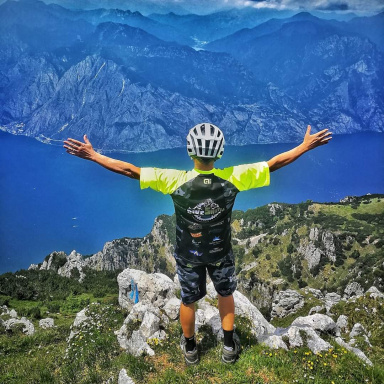
Departing from Malè, we go up Val di Rabbi until after S.Bernardo, where we keep the Val Cércen forest road, from there it is about 11 km and 1300 of elevation gain, from Malga Cércen Alta up to the Pass we push (or portage). With an assisted bike this part is deadly.
Then the efforts are rewarded with exceptional views. Long and varied descent to Cogolo di Pejo and from there all bike to Malè.
Local weather
Thu 00:00

19 °C
Thu 12:00
26 °C
Fri 00:00

23 °C
Fri 12:00

24 °C
Sat 00:00

17 °C
Sat 12:00
25 °C
Graph
Nearest Routes
30,81 km
Km
+1 571 mt
Vertical meters
Route difficulty
Landscapes
2024/09/14
- Italy - Trentino-Alto Adige/Südtirol, TN 66,22 km
Km
+2 400 mt
Vertical meters
Route difficulty
Landscapes
2024/09/14
- Italy - Trentino-Alto Adige/Südtirol, TN 66,56 km
Km
+1 900 mt
Vertical meters
Route difficulty
Landscapes
2024/09/14
- Italy - Trentino-Alto Adige/Südtirol, TN 22,04 km
Km
+1 064 mt
Vertical meters
Route difficulty
Landscapes
2023/03/08
- Italy - Trentino-Alto Adige/Südtirol, TN 73,82 km
Km
+2 850 mt
Vertical meters
Route difficulty
Landscapes
2023/03/04
- Italy - Trentino-Alto Adige/Südtirol, TN 25,21 km
Km
+1 210 mt
Vertical meters
Route difficulty
Landscapes
11,72 km
Km
+11 mt
Vertical meters
Route difficulty
Landscapes