Italiano
 Deutsch
Castelnuovo di Val di Cecina Trail Area

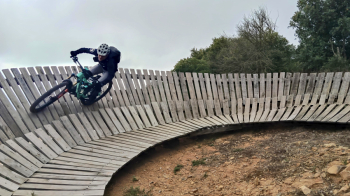
We set off from Castelnuovo Val di Cecina on a dull morning, shrouded in thick fog that dampens the colors and makes the atmosphere almost suspended. The first few rides flow quickly as we move away from the town and into the damp woods, where the silence is broken only by the sound of wheels on the wet ground. The first descent, Bruciano, comes soon: the water-soaked bottom and autumn leaves make each turn more slippery and treacherous than usual. Then it's the turn of the second descent, Infernacci, more closed and winding, which in the fog takes on an almost mystical tone, as if the forest swallows the trail as we proceed.
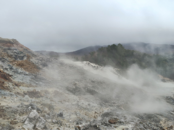
From here we move toward Monterotondo Marittimo, entering the geothermal area of the Biancane Park. Fog mingles with the natural fumaroles, creating a surreal landscape: vapors rising from the ground, rocks warm to the touch and the trail creeping through white puffs as if we were pedaling inside another dimension. The trail carved inside the fumaroles is a unique experience: hot soil, sulfur in the air, muffled sounds.
We then return toward Castelnuovo to tackle the last two descents. The Devils' Hague welcomes us with its classic S2 difficulty, punctuated by a few S3 passages, which today, with the bottom carpeted with leaves and completely hidden from view, requires maximum attention. Every rock and root seem to lurk beneath the damp layer of foliage. Stregaia, the last technical effort of the day, is even more treacherous: poor visibility, treacherous terrain and continuous changes of pace that force you to ride with precision and sensitivity.
All that remains is the last climb, about 3 steady kilometers that bring the legs back to work. The fog closes behind us as we finally return to our starting point, with the satisfaction of having completed a challenging, evocative ride made all the more intense by the gloomy atmosphere of the day.